In East Tirol a dangerous situation has developed as a consequence of extraordinary amounts of snowfall plus ongoing wind impact and rain. This has led to the highest rank of risk being assigned: very high avalanche danger.
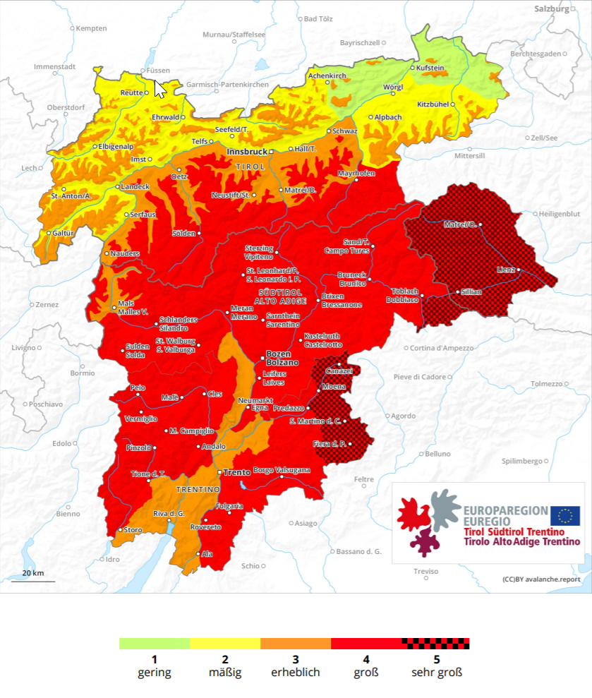 |
| Update from 06.12.2020 8:00 am: In the EUREGIO very high avalanche danger prevails regionally. |
In the mountains there, between 150 and 200 cm of fresh snow has been registered, in the furthermost southern regions as much as 250 cm. Today, 6 December, yet another round of precipitation will strike in thunderstorm manner from the south. The ZAMG Weather Service expects an additional 100-120 cm of fresh snow in East Tirol, falling at high intensity. (According to ZAMG, the amount of precipitation will break all records in Lienz. In the history of measurement since 1880, the entry of November 1966 (245 cm) is the record. With certainty this amount will be exceeded.)
 |
| Visible on the map: distribution of precipitation in Tirol. The further south you go, the heavier the precipitation. At right: top spot of precipitation was southern East Tirol (Porzehütte). |
Damage-causing avalanches
In Virgental yesterday evening (5 December) an avalanche was triggered north of Hinterbichl which plummeted into a utility building and a home, causing damages. Today (6 December) we received reports of a damaging avalanche in Defereggental, where houses were also struck. Persons were not injured. For details, click here:
It can be assumed that in the interim other damage-causing avalanches have also released. The poor visibility and wide-ranging road closures hamper a comprehensive picture of avalanche releases.
Extremely large-sized avalanches, especially in high-altitude starting zones
The biggest worry currently: extremely high altitude starting zones where prior to the snowfall there existed a more-or-less cohesive, area-wide snowpack. Through the additional weight load of the fresh snow, fractures in the old snow can be generated and subsequently sweep the entire snowpack away as a slab. This applies particularly to steep shady slopes above approximately 2400 m and steep sunny slopes above about 3000 m.
Also at lower altitudes, however, even if more typical above the timberline, slab avalanches will continue to trigger naturally. This is due to the type of precipitation: resembling thunderstorms, during which layers of graupel are deposited which thereby generate a potential weak layer inside the snowpack. Moreover, the just launched drop in temperatures is causing the fresh snow to be more loosely packed; thus, this too can provide a weak layer for potential slab avalanches, particularly amid varying wind impact.
In a nutshell: this is a highly complex interaction of varied, not easily evaluated parameters of impact, leading to the possibility of additional damage-causing slab avalanches. The likelihood of their triggering is expected to swiftly decrease starting this evening, as precipitation slackens off, temperatures gradually drop, and the wind eases.
Glide-snow avalanches
An additional important threat on grass-covered slopes below approximately 2600 m: glide-snow avalanches. Some of our observers have reported glide cracks in the snowpack in these locations, and fish-bone openings on the surface, frequent indicators of imminent avalanche triggerings.
Situation in the regions along the Main Alpine Ridge
The situation in the Central Alps is also quite tense. According to ZAMG, another 40-70 cm of fresh snow can be expected again today (6 December). High danger has been assigned to those regions. For further details, see today’s Avalanche Bulletin.
What’s on the way?
Over the next few days, glide-snow avalanches will trigger, often in the major areas of precipitation (snowfall AND rainfall). In our experience, the frequency of triggerings will decrease day by day. It remains impossible to forecast the times/moments of such releases.
Apart from the glide-snow problem, avalanche danger levels are expected to swiftly diminish. Subsequently, the focal point will be on snowpack-surface avalanche problems, which are far easier to evaluate. In the northern regions where there has been little precipitation, on the other hand, the old snow problem on north-facing slopes above the timberline remains a threat.