Friday, 3 March 2023

Generally favorable avalanche conditions – Little snow in many places – Danger Pattern “cold on warm” frequently developing

 Summing it up


Since yesterday, 01.03.2023, the avalanche danger level in Tirol has been low. We assume there are only few danger zones where avalanches can be triggered, if at all, then on shady slopes at high altitudes. Nevertheless, we are currently observing the development of a potential weak layer due to Danger Pattern “cold on warm” (dp.4). In isolated cases this layer could become a problem during the next few days. We are training a sharp eye and lots of research on just where this might happen. In this blog you can read about the latest stage of our knowledge regarding dp.4.


Finally snow - esp. in the northern and eastern regions

Last week bore the stamp of initial snowfall, striking mainly in the northern and eastern regions of the land where generally 30-50cm of fresh snow was registered. Further south the amounts of fresh fallen snow were noticeably less. Due to low temperatures the snow was quite loose. Winds generated snow transport. We were often confronted with a new-snow problem (where danger zones are not visible to the naked eye). In the regions with least precipitation, on the other hand, a snowdrift problem dominated (wind-loaded masses recognizable in open terrain, could be circumvented). During the last few days, beautiful weather prevailed, while southern regions were overcast. There was some snow in the south on 01-02 March, mostly 5-10cm.


72h-Neuschneesumme zwischen Freitag, den 24.02. Montag, den 27.02.2023
72-hr fresh snow between Friday 24.02 and Monday 27.02.2023


Etwas Schnee im Süden: 24h-Neuschneesumme zwischen 01.03. und 02.03.2023
Some fresh snow in the south: 24-hr snowfall between 01.03. and 02.03.2023


Eine schöne Winterlandschaft nach den Schneefällen ab dem 24.02.2023. Dennoch: Bei der Abfahrt muss man immer noch auf möglichen Steinkontakt achten - Zentrale Lechtaler Alpen (Foto: 28.02.2023)
A gorgeous winter landscape following the snowfall from 24.02.2023. Nevertheless, still danger of rocks on the descent. Central Lechtal Alps. (photo: 28.02.2023)


Toller Pulverschnee in den Westlichen Kitzbüheler Alpen (Foto: 28.02.2023)
Superb powder in western Kitzbühel Alps (photo: 28.02.2023)


Following the snowfall, increasingly frequent loose-snow avalanches were observed in extremely steep terrain. Slab avalanches were generally small, fractured beneath the fresh fallen snow (cold, loose snow blanketed by freshly generated drifts). In addition, the snow tended to slide over steep grass-covered slopes.


Lockerschneelawinen in den Westlichen Lechtaler Alpen (Foto: 01.03.2023)
Loose-snow avalanche in western Lechtal Alps (photo: 01.03.2023)


Kleine spontane Schneebrettlawine, vermutlich vom 26.02. in der Grieskogelgruppe (Foto: 02.03.2023)
Small naturally triggered slab avalanche, presumably on 26.02. Grieskogel Massif (photo: 02.03.2023)


Gleitschneerutsche in den Östlichen Lechtaler Alpen (Foto: 28.02.2023)
Glide-snow slide in eastern Lechtal Alps (photo: 28.02.2023)


Danger Pattern "cold on warm" (dp.4)

Danger Pattern “cold on warm” occurs whenever an initially moist or wet snowpack surface gets blanketed by cold snow. Due to the great temperature disparity over small spaces, an expansively metamorphosed (faceted) layer can develop with a bit of delay. Currently we see such a development taking place. This process is important in the northern and eastern regions which recently had heavy snowfall. There, in addition to the formation of a potential weak layer, there is also the crucial slab. Today, 02.03, two reports about settling noises arrived at headquarters which can in all likelihood be attributed to this process (regions Kalkkögel and Sellrain). Dp.4 may also be the cause of an avalanche in the Kalkkögeln, presumably on 28.02 in the afternoon or 01.03 in the morning.


Voraussetzungen für "kalt auf warm": Ellipse: Feuchte Schneeoberfläche. Danach Schneefall und fallende Temperaturen
Prerequisites for “cold on warm:” ellipse denotes moist surface; then snowfall plus dropping temperatures.


Current estimate for pinpointing “cold on warm”

At the presenet moment there are relatively few reports of a potential “cold on warm” problem. We base this not only on reports, but also on our own open terrain explorations and snow profiles.

The forming of a threatening weak layer is currently most possible, in our opinion, in the following zones or is already the case there:
  • North, altitudes 2100m-2300m
  • East / Northeast and West and Northwest: 2100m-2500m
  • South 2500m and above

Please assist us

We have assigned this project to all our observers: be attentive to this development over the next few days and inform us. The more comprehensive our information is, the clearer the overall picture becomes. For that reason, we turn to those of you who like to have a look inside the snowpack. What interests us most is whether faceted crystals have formed near the melt-freeze crust which formed last week. Of course, a stability test would be even better, e.g. a quickly executed ECT. We look forward to lots of reports from you, mail them to  lawine@tirol.gv.at  


Ein Blick in die Schneedecke hilft, die Entwicklung von gm.4 besser einzuschätzen - Venedigergruppe (Foto: 01.03.2023)
A glance into the snowpack helps us to assess the development of dp.4 - Venediger Massif
(photo: 01.03.2023)


Schneebrettlawine mit einer Einfahrtsspur eines Snowboarders (oberer Anrissbereich zwischen den Felsen) auf 2300m Nord. (Foto: 01.03.2023)
Slab avalanche with entry track of a snowboarder (upper fracture zone between rocks) at 2300m North (photo: 01.03.2023)


Vergleichsfoto zu obigem Foto: Am 28.02. nachmittags war an dieser Stelle nur eine querende Spur zu sehen. Die Lawine war noch nicht abgegangen. (Foto: 28.02.2023)
Photo for comparison: on 28.02 in the afternoon, only one traverse track could be seen. The avalanche had not yet triggered. (photo: 28.02.2023)


Der Pfeil zeigt auf eine dünne kantige Schicht unterhalb einer dünnen Schmelzkruste. Der Stabilitätstest zeigte hier stabile Verhältnisse. Dies kann allerdings auch mit der lockeren Schneeauflage zu tun haben. Nord, 1940m
Arrow points to a thin faceted layer beneath a thin melt-freeze crust. Stability test showed stable conditions; however this could be due to the looseness of the snow. North, 1940m


Auf 2720m NW in der Venedigergruppe findet man zwar auch kantige Kristalle unter einer dünnen Schmelzkruste, allerdings dürfte diese nichts mit gm.4 zu tun haben. Vielmehr dürfte es sich hier um vormaligen "Noppenpulver" handeln.
At 2720m NW in Venediger Massif there are also faceted crystals beneath a thin melt-freeze crust, but these are probably not from dp.4. Far more likely in this case is the previous “knobby powder.”


An diesem schneearmen Bereich dürften sich die kantigen Kristalle schon länger zurück gebildet haben. Zusätzlicher Effekt von gm.4 nicht ausgeschlossen. Dennoch: Nur Teilbrüche, allerdings auch kein gutes Brett darüber.
In this spot with little snow, faceted crystals probably formed quite a while earlier. Additional effect of dp.4 cannot be ruled out. Nonetheless: only partial fractures. Notable: no sufficient slab on top of it.


Teilbrüche unterhalb der oberflächennahen Schmelzkruste. West, ca. 1750m
Partial fractures above superficial melt-freeze crust. West, about 1750m


Assorted tid-bits

There are also other interesting observations to report. Over the last few days we have had quite good conditions for forming surface hoar. On the one hand, the fog (especially in the southern regions). On the other, due to thermic air currents (“Nigg Effect”).


Wärmere Luft steigt auf. Wolken streifen über die Gipfel. Gute Voraussetzungen für den "Nigg"-Effekt. Venedigergruppe (Foto: 01.03.2023)
Warmer air masses rising. Clouds brush the summits. Good prerequisites for the “Nigg” Effect.
Venediger Massif (photo: 01.03.2023)


Kammnaher Oberflächenreif in der Samnaungruppe auf ca. 2500m (Foto: 02.03.2023)
Surface hoar adjacent to a ridgeline (“Nigg” Effect) in the Samnaun Massif at about 2500m
(photo: 02.03.2023)


Persistent lack of snow

GeoSphere Weather Service (formerly ZAMG) informed us in one report that this winter has been very mild. In the lowlands it was the sixth warmest winter in (measurement) history. In the mountains, it lay in 12th place. Furthermore, western Austria was 15-60% drier than average. Both phenomena, mild weather and low precipitation, are the causes of the below-average amounts of snow.

Keine Seltenheit bei Skitouren im heurigen Winter: Zumindest während kurzer Passagen müssen die Skier getragen werden. (Foto: 02.03.2023)
Not unusual on ski tours this winter: at least for short passages, you have to carry your skis.
(photo: 02.03.2023)


Untypisch für diese Jahreszeit: Schneelage in den Zentralen Stubaier Alpen (Foto: 24.02.2023)
Above snow situation is not at all typical for this juncture of the season. Central Stubai Alps
(photo: 24.02.2023)


What can we expect?

We are keeping a sharp eye on the development of dp.4, since it could mean increasing avalanche danger in the regions which recently had the most snow.

Friday, 24 February 2023

Much too little snow for this juncture of the season – Persistent weak layer esp. on very steep shady slopes near ridgelines – Minor snowdrift problem on the weekend

 In short:


The lack of precipitation this winter is quite striking in the snow cover. For this juncture of the season there is much too little snow on the ground, not only here in Tirol but in far-reaching parts of the Alps. See also the Blog of our colleagues in Switzerland.

Avalanche danger levels are moderate, particularly on the Main Alpine Ridge and a little north of there above about 2200m. That is because of isolated avalanche prone locations where winter sports enthusiasts can still trigger releases. Please refer to our last Blog. 

On the weekend some fresh snow will be added to it. Avalanche danger will increase somewhat from region to region. Above the timberline, approximately, freshly generated snowdrift accumulations require caution.


(Much too) little snow

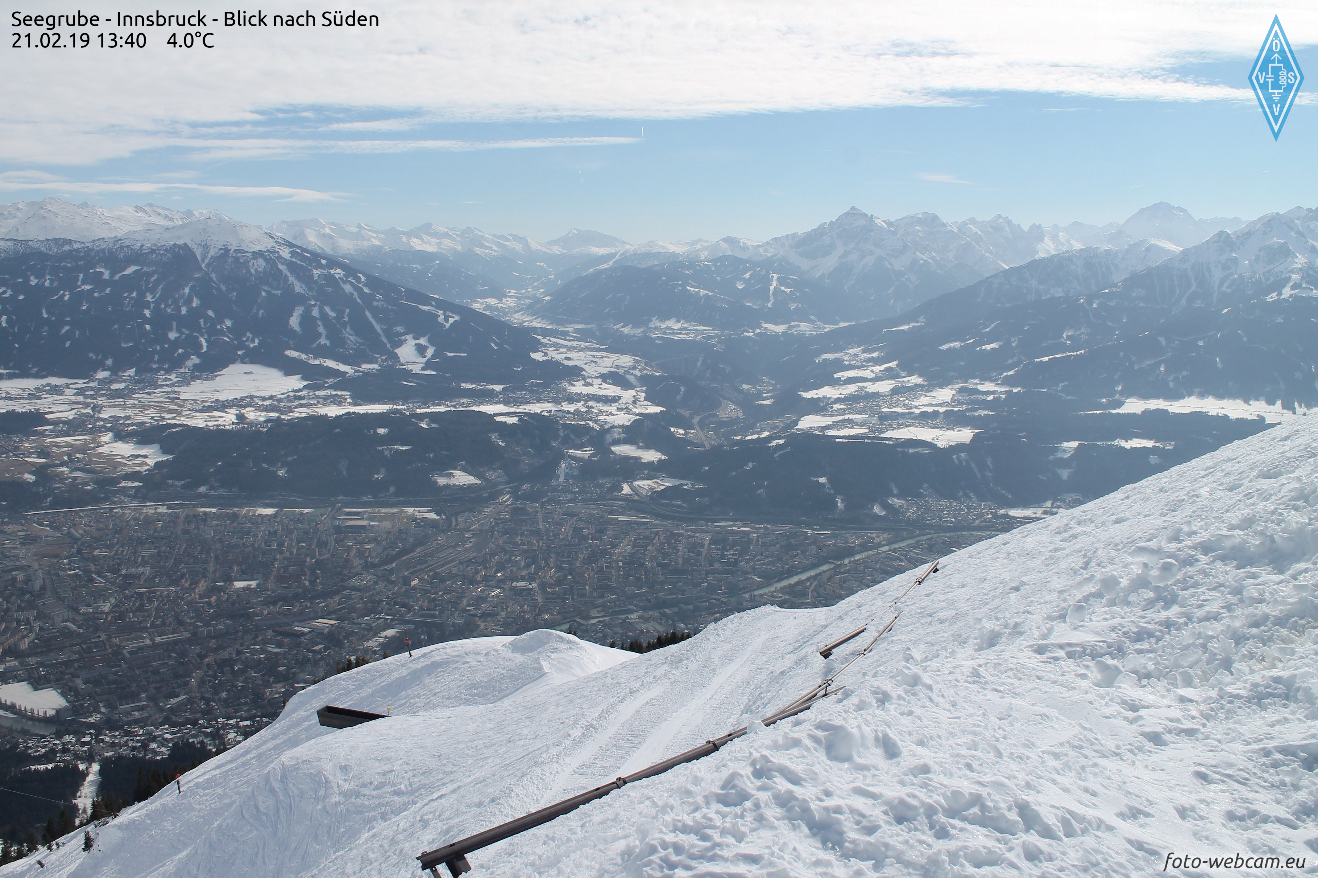
For the next few days, a bit of snowfall is in view but that does not much change the overall snow picture, i.e. dearth of snow. The puny snow depths can most easily be appreciated in a comparison of wetcam photos and with long-term records of our observers:


Die Grafik zeigt die von unseren Beobachtern auf der Nordkette gemessenen Schneehöhen seit 1973. Oberer Bereich: bisherige Maxima - Unterer Bereich: bisherige Minima - Graue Linie: Mittelwert - Linie in magenta: Schneehöhe des Winters
The graph shows snow depths measured by observers on the Northern Massif since 1973. Upper border: maxima till now. Lower border: minima till now. Gray line: medium value. Line in magenta: snow depths this winter


Schneehöhe auf der Seegrube oberhalb von Innsbruck mit Blick ins Wipptal (22.02.2023)
Snow depths on the Seegrube above Innsbruck looking towards Wipptal (22.02.2023)


Vergleichsfoto vom 21.02.2019
For comparison, a photo from 21.02.2019


Ähnlich in weiten Teilen Tirols: An Sonnenhängen findet man bis in größere Höhen kaum mehr eine zusammenhängende Schneedecke (Foto: 21.02.2023; (c) Stefan Zangerl)
Similar pictures throughout Tirol: on sunny slopes, hardly a cohesive snowpack up to high altitudes.
(photo: 21.02.2023; (c) Stefan Zangerl)


Die Schneearmut macht sich auch auf den Gletschern bemerkbar, wo für die Jahreszeit eine überdurchschnittlich hohe Spaltensturzgefahr besteht - Gurgler Gruppe. (Foto: 21.02.2023)
A lack of snow is also noticeable on the glaciers, where a very high danger of falling into crevices threatens for this juncture of the season.  Gurgler Massif  (Foto: 21.02.2023)


Persistent weak layer in isolated places, esp. near ridgelines on very steep shady slopes

In the interim, quite favourable conditions reign, as far as avalanche danger is concerned. However, there are still isolated danger zones where slab avalanches can be triggered. These spots are found especially on very steep shady ridgeline slopes above about 2200m. Avalanches can be triggered especially wherever there have been only few winter sports enthusiasts this year, and in transition zones from shallow to deep snow. For further details, please consult our last Blog.  


Schneeprofil im Bereich einer kürzlich von Wintersportlern ausgelösten Schneebrettlawine in den Nördlichen Zillertaler Alpen (21.02.2023)
Snow profile near a recent slab avalanche triggered by a winter sports enthusiast in northern Zillertal Alps.
 Persistent weak layer.  (21.02.2023)


Outlook: fresh snowfall will lead to a small snowdrift problem

Geosphere Austria weather service forecasts snowfall in the next few days. In general, about 20cm is expected at high altitudes, up to 40cm from place to place. The snowfall will be accompanied by strong-velocity winds, mostly from the west.


72h Neuschneeprognose 24.02.-26.02.2023
72-hr fresh snow forecast 24.02.-26.02.2023

This will lead to a generally minor snowdrift problem above the timberline, which could be somewhat more pronounced in the major areas of precipitation. Caution urged in wind-protected, very steep slopes behind abrupt discontinuities in the terrain.

Fresh snow and freshly generated snowdrifts will be deposited atop a highly diversified snowpack surface:
  • melt-freeze crusts which are more or less capable of bearing loads on steep sunny slopes and shady slopes up to intermediate altitudes;
  • knobby powder in wind-protected shady terrain and at high altitudes in wind-protected flat terrain
  • snowpack surfaces which were recently hit by wet-snow slides
  • snowpack surfaces showing high wind impact at high altitudes
Fresh snow and snowdrifts are expected to bond quite well with the old snowpack. The bonding is least favourable of all, by comparison, where there was knobby powder up to the time of precipitation.


Tragfähige Schmelzkruste im besonnten Gelände in den Alpeiner Bergen (Foto: 16.02.2023)
Melt-freeze crust capable of bearing loads in sunny terrain, Alpeiner mountains (photo: 16.02.2023)


Noppenpulver in der Silvretta (Foto: 21.02.2023)
Knobby powder in the Silvretta (photo: 21.02.2023)


Eine von kleinen Nassschneerutschen beeinflusste Schneeoberfläche. Östliches Karwendel (Foto: 22.02.2023)
Snowpack surface showing impact from a small wet-snow slide. Eastern Karwendel
(photo: 22.02.2023)


Wie vom Fotografen dieses Bildes treffend geschildert: Der Wind lag am vergangenen Wochenende "über Steinverfrachtungsstärke" Region Sellrain-Alpeiner Berge (Foto: 19.02.2023)
As the photographer so aptly put it: Winds last weekend were blowing at “above rock-transport velocity.” Region Sellrain-Alpeiner mountains (photo: 19.02.2023)


Station Nachtweide - Palinkopf in der Silvretta: Windig wars am vergangenen Wochenende. Freitag, 17.02. und Samstag, 18.02. noch vermehrte Durchfeuchtung und dadurch etwas erhöhte Nassschneeaktivität. In Summe etwas wechselhaft mit auch sehr sonnigen Phasen. Die Temperatur geht nun langsam zurück.
Measurement station Nachtweide - Palinkopf in the Silvretta: it was windy last weekend. Friday, 17.02 and Saturday, 18.02, still a thoroughly wet snowpack and thus, heightened wet-snow activity. All in all, variable conditions with sunny intervals, temperatures receding only slowly.


Niederschlags- und Windprognose samt Entwicklung der Schneefallgrenze für eine der prognostiziert niederschlagsstärksten Regionen, den Zentralen Kitzbüheler Alpen.
Precipitation and wind forecasts including changes in snowfall level for the major region of precipitation,  central Kitzbühel Alps.


Temperaturprognose für die kommenden Tage. Es wird kälter, ab Wochenbeginn steigen die Temperaturen wieder.
Temperature forecast for coming days. It will get colder, but temperatures will rise again starting next week.


For a brief spell: loose-snow avalanches right after the snowfall

When the forecast snowfall comes to an end and solar radiation returns, numerous loose-snow avalanches can be expected on extremely steep slopes. In very isolated cases, small naturally triggered slab avalanches are conceiveable in the major areas of precipitation, particularly on very steep slopes where there are freshly generated snowdrift accumulations plus massive solar radiation with higher daytime temperatures. Those moments of danger are expected to arrive...and then swiftly depart.

Wednesday, 22 February 2023

Persistently treacherous – persistent weak layer

 To start off: 

The persistent weak layer which has persisted for a long period is still of significance for avalanche releases in isolated cases. This was amply demonstrated last week by several avalanche triggerings in which persons were involved.

  • Wednesday, 15.02.2023: negative avalanche Gstreinjöchl, Ridnaun Massif
  • Thursday, 16.02.2023: negative avalanche Pfaffenbichl, western Tux Alps
  • Saturday, 18.02.2023: two negative avalanches Hohe Warte (Schmirn), northern Zillertal Alps
  • Saturday, 18.02.2023: 1 person injured, Hohe Warte (Schmirn), northern Zillertal Alps
  • Sunday, 19.02.2023: negative avalanche Gammerspitze, northern Zillertal Alps
  • Sunday, 19.02.2023: 1 person injured, Geraer Hütte, northern Zillertal Alps
  • Tuesday, 21.02.2023: negative avalanche Hohe Warte (Schmirn), northern Zillertal Alps
What stands out is the conglomeration of avalanche releases reported in the northern Zillertal Alps, four of them near the Hohe Warte. The avalanches were loosed at 2200 - 2600m altitude, mostly on north-facing slopes. East-facing and west-facing slopes are equally endangered. The avalanches were all unleashed in transition zones from shallow to deep snow in very steep to extremely steep terrain.


Danger zones are...where the best skiing is

What is so treacherous in the present situation is the fact that the avalanche prone locations are precisely where the best skiing is to be found. In wind-protected zones at this altitiude and in this aspect there is frequently “knobby powder” to be found, in other words, beautifully skiable, expansively metamorphosed, loose snow. Below that, there still is a “slab” in the relevant places from the last round of precipitation at the beginning of February. Thus, you don’t break through to the ground, as is often the case.

Treacherous, because there are only few danger zones...and they’re not visible to the naked eye

Throughout Tirol, similar such steep slopes in the relevant altitudes and aspect are currently being skied on, without avalanches being triggered. That underscores the low frequency of danger zones in general. Nevertheless - and this is the crucial point - the weak layers lurking inside the snow cover can still be triggered by winter sports enthusiasts in unfavourable circumstances. The steeper the slope and the less-tracked it is this winter, the more frequently this occurs. Caution: terrain which was tracked only after the bout of precipitation at the beginning of February is also endangered. (Tracks don’t mean that this is safer. With a bit of bad luck, you touch a hot spot.)


Lawinenabgänge Hohe Warte: violett: Anfang Februar; magenta: Lawinen vom 18.02. (die längste davon war jene mit der verletzten Person) rot: Lawine vom 21.02.2023; 2500m, NO (Foto: 21.02.2023)
Avalanches Hohe Warte: violet: beginning of February; magenta: avalanches on 18.02 (the longest one was where someone was injured, ending up in the lowermost avalanche zone) red: avalanche on 21.02.2023; 2500m, NE (photo: 21.02.2023)


Lawinenabgänge Gampesspitze (links) und Gammerspitze (rechts) jeweils mit Personenbeteiligung, jeweils unverletzt, 2500m, Nord (Foto: 21.02.2023)
Avalanches Gampesspitz (left) and Gammerspitze (right) each involving persons, no injuries, 2500m, N (photo: 21.02.2023)


Lawine unterhalb der Geraer Hütte: 2200m, West (Foto: 21.02.2023)
Avalanche below Geraer Hütte: 2200m, West (photo: 21.02.2023)


Bezeichnendes Profil für noch vorhandene Problembereiche: Oberflächennah ist das Brett gerade noch ausreichend ausgeprägt (90-70cm); darunter die noch störanfälligen Schwachschichten. Hohe Warte, 2460m, NO, 35° (Weitere Profile, wie immer unter www.lawis.at
Instructive profile for still existing problem zones: near-surface slab just sufficiently pronounced (90-70cm); beneath that, the still prone-to-triggering weak layers. Hohe Warte, 2460m, NE, 35°
(for additional profiles, as always see www.lawis.at 

Friday, 17 February 2023

Quite good conditions in general. Slight loss of firmness in places due to solar radiation and daytime warming

To sum it up: Danger zones especially in little-tracked shady very steep terrain

During the last few days, Avalanche Headquarters Tirol received only isolated reports of avalanches involving persons (no injuries). Moreover, most snowpack analysis in the interim demonstrates a lack of tension inside the snowpack. Thus, we can assume there are only limited avalanche prone locations in open terrain where slab avalanches can now be triggered, particularly in shady, very steep terrain which has been not much tracked over the winter. On sunny slopes we assume very isolated danger zones for dry-snow slab avalanches around 2500m altitude.


On sunny slopes: high caution if they are wet

In the last few days avalanche danger levels increased slightly. In extremely steep sunny terrain we observed isolated moist loose-snow slides. On steep grass-covered slopes, somewhat more frequent glide-snow slides and small glide-snow avalanches occurred.


Die roten Pfeile zeigen auf kürzlich abgegangene Lockerschneerutsche. Die blaue Ellipse umrahmt einen Gleitschneerutsch, die Ellipse in magenta zeigt eine ca. 10 Tage alte Schneebrettlawine. Westliche Tuxer Alpen. (Foto: Hubert Gogl, 15.02.2023)
Red arrows point to recent loose-snow slides. Blue ellipse encircles a glide-snow slide, the magenta ellipse a slab avalanche about 10 days prior. Western Tux Alps. (photo: Hubert Gogl, 15.02.2023) 


Gleitschneemäuler in den Östlichen Lechtaler Alpen (Foto: 15.02.2023)
Glide-cracks in eastern Lechtal Alps (photo: 15.02.2023)

Firn snow

Following nights of clear skies, a melt-freeze crust capable of bearing loads forms on very steep sunny slopes, especially at intermediate altitudes. Due to the dry air, this is slower to soften up during the daytime. If you planned your time carefully, pure firn-snow enjoyments awaited. Weather conditions will now become less stable, firn snow will be found more seldom.


Firnabfahrt in den  Östlichen Lechtaler Alpen (Foto: 15.02.2023)
Descent through firn snow in eastern Lechtal Alps (photo: 15.02.2023)


Knobby powder on shady slopes

Away from sunny slopes in a few wind-impacted zones you can find a loosely-packed, roughed-up snowpack surface. We refer to this as “knobby powder” which is excellent to ski through. (Caution: sharks are a threat - rocks just beneath the surface.)


Im Noppenpulver lassen sich schöne Schwünge ziehen (Foto: 12.02.2023)
In knobby powder your ski turns are more elegant. (photo: 12.02.2023)

 
Weather development

According to Geosphere Austria (formerly ZAMG), conditions are becoming more variable, the air masses more moist. Nocturnal longwave outgoing radiation will decrease. Due to more shade during the daytime hours there will also be less energy penetrating the snowpack, unless there is more sunshine than expected. In that case, due to heightened air moisture and solar radiation more energy can penetrate the snow cover. For that reason, it’s important to keep your eye on the degree to which the snowpack becomes moist or wet, since if water seeps for the first time down to the often encrusted layer of faceted crystals at about mid-level in the snowpack, it will lead to more loss of firmness and heightened likelihood of slab avalanches triggering. The process is accelerated by the shallowness of the snowpack for this juncture of the season.


Additional information


Immer noch liegt für die Jahreszeit vielerorts viel zu wenig Schnee. Die obere Grafik zeigt die bisher gemessenen Maxima und Minima, sowie den Mittelwert seit 1960. Magenta: Aktueller Winter
Still too little snow for this juncture of the season. Top graph: maxima and minima to date, and middle value since 1960. Magenta: this winter


Das Wetter der vergangenen Woche: Kurze Eintrübung ab Samstag, 11.02. nachmittags, sonst meist prächtig schönes Winterwetter. Temperatur geht wieder leicht zurück
Last week’s weather: brief period of gray skies starting Saturday, 11.02 afternoon; otherwise generally splendid wintery weather. Temperatures dropping slightly.


Temperaturkurven bei Schneeprofilen geben Aufschluss über die Temperaturreserven der Schneedecke. Je näher bei 0°C, desto rascher kann eindringendes Wasser in tiefere Schichten eindringen und die Schneedecke schwächen.
Temperature curves in snow profiles reveal the temperature reserves inside the snowpack. The closer we get to 0°C, the quicker water seepage can penetrate to the deeper layers and weaken the snowpack.

Monday, 13 February 2023

Persistent weak layer in some places – Slight daytime danger cycle for avalanche risks due to solar radiation and rising temperatures

Before all else: Besides persistent weak layer problem, daytime loss of snowpack-surface firmness


Last week’s biggest threat, the persistent weak layer, remains with us above 2000m. In the interim, frequency of avalanche prone locations where slabs can be triggered has diminished significantly. Avalanches are mostly triggerable on very steep slopes in transition zones from shallow to deep snow. Therefore: restraint and caution in untracked, very steep terrain is imperative.

To this risk must now be added the increasing degree of snowpack wetness during the course of the day. On very steep to extremely steep sunny slopes, the snowpack can forfeit its firmness thereby. But if backcountry tourers plan their time carefully, the reward at intermediate altitudes will be great firn snow.


Forfeiting firmness of snowpack due to solar radiation and higher temperatures

Splendid winter weather including higher temperatures and intensive solar radiation has its impact: at very least the near-surface part of the snowpack becomes thoroughly wet. Where the snow is shallow, wetness penetrates much deeper. Water seepage in the snowpack generates a loss of overall firmness. That means the melt-freeze crust which formed during the night (and was often capable of bearing loads) gets softened up. 

Three scenarios are conceivable:
  • On extremely steep slopes, moist or wet loose-snow avalanches trigger.
  • These loose-snow avalanches burden the snowpack on their plummet path so much that slab avalanches are triggered.
  • Water seeps down to the faceted layer which caused the persistent-weak-layer problem (beneath a thin melt-freeze crust). Thereby the weak layer loses its firmness. The likelihood of a slab avalanche triggering thereby increases. This scenario is especially applicable to extremely steep S/SE to S to S/SW facing slopes where the snow is shallow at intermediate altitudes.

Die aktuelle Situation


Steigende Temperaturen. Steigende Schneeoberflächentemperaturen mit entsprechendem Tagesgang.
Rising temperatures. Rising snowpack-surface temperatures and the corresponding daytime danger cycle.  


The curve of snowpack-surface temperature is becoming flatter at the measurement stations. That demands heightened attentiveness to the increasing wetness of the snowpack.


Avalanche Kellerjoch on 12.02.2023

Yesterday (12.02.2023) an avalanche near the Kellerjoch in the direction of Naunzalm was reported. Since it was not certain if persons were buried in snow, a search operation was initiated that was hampered by subsequent avalanches. In the end, the all-clear signal could be given, no one was buried in the snow.

The analysis of this avalanche proved to be highly interesting, since we had no reason to expect a naturally triggered slab avalanche based on available data. However, as is so often the case, the explanation was simple...it lies in the devilish details. On Saturday, cloudbanks which moved in during the afternoon caused an intense moistening of the snowpack. We assumed that at least the latter part of the night would have clear skies, but that was definitely not what happened in the Lower Inn Valley. In the accident zone, nocturnal skies were heavily overcast with only tiny gaps. Thus, the prerequisites for longwave outgoing radiation and re-firming up of the superficially moistened snowpack were lacking. Solar radiation and higher daytime temperatures then generated a thoroughly wet snowpack, much wetter than anticipated. (By comparison, today on 13.02.2023 we have a better starting situation due to very clear nighttime skies and highly effective outgoing radiation.)


Lawinenabgänge Kellerjoch vom 12.02.2023. Extrem steil südseitig. Anrissgebeit um 2100m.
Avalanche Kellerjoch on 12.02.2023. Extremely steep south-facing slope. Fracture at 2100m.


Webcambild Bremerhütte Richtung Osten. Samstag nachmittags, als die Wolkendecke kurzfristig am dichtesten war. Gebietsweise bildete sich aufgrund dieser Wolkenbedeckung übrigens an der Schneeoberfläche eine dünne Eislamelle (v.a. oberhalb etwa 2500m), während der Nacht vom 11.02. auf den 12.02. zusätlich auch noch Oberflächenreif.
Webcam shot from Bremerhütte towards the east. Saturday afternoon, when clouds were at their heaviest for a brief spell. Incidentally, a thin film of ice formed on the snowpack surface (esp. above 2500m) due to this cloud cover. During the night on 11.02, surface hoar formed on top of that.


Upshot

Please pay close heed to snowpack wetness in the next few days. Only on-site is it possible to determine this.

Apart from that: wherever a melt-freeze crust which is capable of bearing loads has formed during the night, you need to pay close attention to potential risks of taking a fall in steep terrain...otherwise there is awesome firn snow to be enjoyed (with good time planning).


Eines der möglichen Szenarien für die kommenden Tage: Lockerschneelawine löst Schneebrettlawine aus. (Foto: 12.02.2023)
One of the possible scenarios for the next few days: loose-snow avalanche triggers a slab avalanche.
(photo: 12.02.2023)