Tuesday, 22 November 2022

Winter sports enthusiasts, beware! At high altitudes avalanches easily triggered in some regions.

 Cold front bringing snow


After an initially warm, then variable November it is snowing down to low altitudes in widespread parts of Tirol. The snowfall will be heaviest today (22.11), tomorrow it is expected to taper off everywhere. According to ZAMG Weather Service the main regions of precipitation lie in the Tux and Zillertal Alps, and the northern and southern parts of East Tirol, where up to 40 cm of fresh snow is expected at high altitudes. Southern Ötztal and Stubai Alps should get up to 30 cm, elsewhere 20 cm is anticipated generally.


48-hr fresh snow forecast. Main areas of precipitation lie in the southeastern regions.


Southerly winds shifted to westerly/northwesterly, blowing mostly at moderate strength. They will intensify significantly at high altitudes over the coming days. Main wind direction will remain W/NW.


Windprognose für Mittwoch, 23.11. 20:00 Uhr
Wind forecast for Wednesday, 23.11. 8:00 pm


Considerable avalanche danger at high altitudes

The combination of snowfall, wind and the current snow layering is causing a significant increase in avalanche danger. At high altitudes, where the cohesive area-wide snowpack has persisted, we assume that avalanche danger will be considerable.  Wherever snowfall is heaviest are the least favorable regions of all. Danger increases with ascending altitude. Shady slopes tend to be at greater risk. Sunny slopes need to be evaluated critically, particularly near ridge lines and in high alpine terrain in general.


Ein Blick zurück: Wechselhaftes Wetter mit wiederkehrenden Niederschlägen, teilweise auch in Form von Regen.
A glance back: variable weather conditions, recurrent precipitation, sometimes as rain


The snowpack

The snowpack is a reflection of the sequence of weather conditions. Appropriately, we find a series of crusts and soft layers, the latter frequently composed of loose, faceted crystals, even depth hoar in some places. This constitutes a serious weak layer for the mass of fresh snow which lies on top of it (impacted by wind). The additional load of one single winter sports enthusiast can be enough to disturb the weak layer and trigger the release of a slab.


Schneeprofil in der Gurgler Gruppe vom 19.11.2022. 3065m, NW, 34° Mögliche Schwachschichten befinden sich in Oberflächennähe
Snow profile, Gurgl Massif, 19.11.2022. 3065m, NW, 34° Potential weak layers near the surface.


Schneeprofil in der Weißkugelgruppe vom 21.11.2022. 3050m, SO, 33°. In großen Höhen findet man auch im besonnten Gelände zumindest eine mögliche Schwachschicht für Schneebrettlawinen.
Snow profile in Weisskugel Massif, 21.11.2022. 3050m, SE, 33°.  There is at least one potential weak layer for slab avalanches even in sunny terrain at high altitudes.


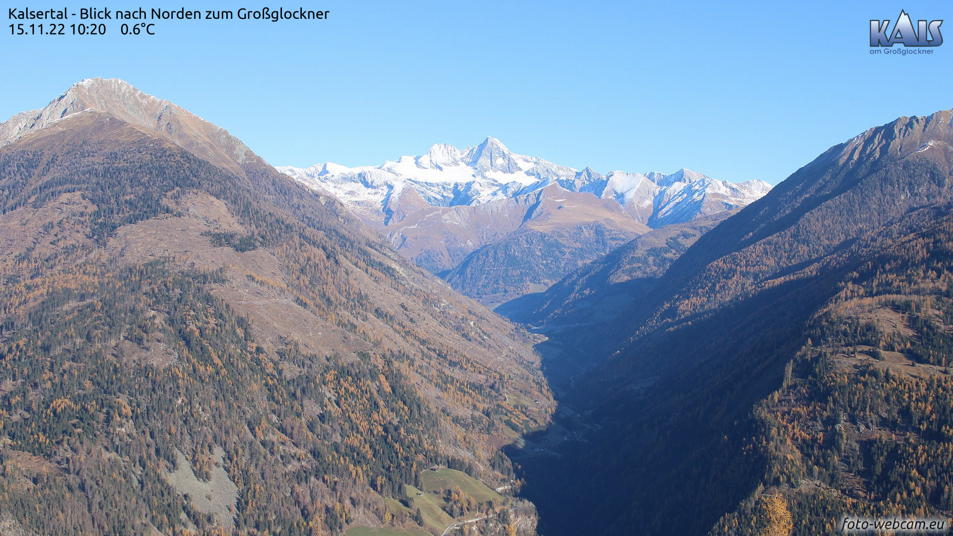
Web camera photos are extremely helpful in determining whether there was a cohesive area-wide snowpack prior to the current snowfall. Here are photos of where that was the case. More details at foto-webcam.eu.   


Blick ins Tuxertal, einem der bisher schneereichsten Gebiete Tirols. Foto vom 15.11.2022
View into Tux Valley, a region that has already had much snow. Photo from 15.11.2022


Hochalpines Gelände von 2800m aufwärts in der Weißkugelgruppe
High alpine terrain above 2800m in the Weisskugel Massif

Nördliches Osttirol. Südhänge waren bis in große Höhen aper.
Northern East Tirol. South-facing slopes were bare of snow up to high altitude.


In den Lienzer Dolomiten und am Karnischen Kamm lag vor den Schneefällen schattseitig bereits Schnee. Unseren Infos nach ist dieser oberflächig verkrustet, darunter häufig locker.
In the Lienz Dolomites and on the Carnic Ridge there was snow on the ground prior to the current snowfall. Our photos reveal it was encrusted on the surface, often loose below the crust.


A plea

In many places there is at least one ugly and threatening weak layer at high altitudes, on top of which is then a well-bonded mass of (fresh) snow. Thus: ideal prerequisites for a slab release. Due to the shallow covering of the weak layer, it can be triggered with relative ease by winter sports enthusiasts. Therefore: be careful, attentive and restrained in the mountains!

By the way, for a brief spell we are going to observe increasingly frequent glide-snow slides on grassy slopes in the regions where snowfall is heavy. In addition, loose-snow avalanches are expected in extremely steep terrain.

Saturday, 5 November 2022

Beware snowdrifts in high alpine terrain. Also loose-snow and glide-snow slides.

Cold front brings snowfall, most in northern Zillertal Alps

Over the last 24 hours there has been precipitation throughout Tirol, above approximately 1200 m as snowfall. Maximum precipitation was registered in the northern Zillertal Alps: as much as 40 mm from place to place. Widespread 10-20 mm was registered. This corresponds to approximately 10-20 cm of fresh snow. In the heights there were frequently strong winds blowing, initially southerly, then northerly.


Neuschneezuwachs der Kaltfront vom 04.11.2022
Increase in fresh snow delivered by the cold on 04.11.2022


Ein ähnliches Bild zeigt die Karte der 24h-Niederschlagssumme (04.11. auf 05.11. 08:00 Uhr) von Hydro Online.
A similar picture in this 24-hr overall snowfall map (04.11 - 05.11) by Hydro Online


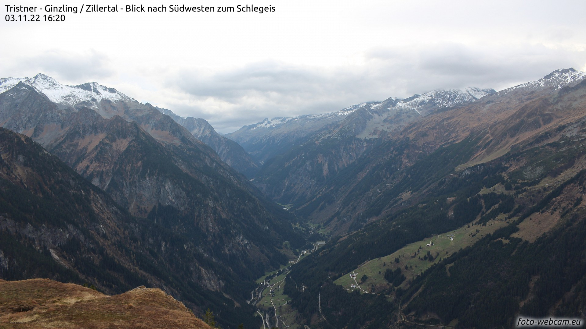
Nördliche Zillertaler Alpen vor Eintreffen der Kaltfront
Northern Zillertal Alps before the cold front arrived


Nördliche Zillertaler Alpen nach Eintreffen der Kaltfront - wohl nur ein kurzer winterlicher Eindruck
Northern Zillertal Alps after the cold front arrived. A brief foretaste of winter...


Effects of snowfall on avalanche danger

One potential avalanche danger can be observed widespread in the regions with the most recent snowfall. It stems from freshly generated snowdrift accumulations in shady, very steep terrain, namely above about 2800 m. The snowdrifts were deposited frequently on a weak surface layer of faceted crystals from October. Currently, small-to-medium sized slab avalanches can be expected. These releases can be triggered by the weight of a winter sports enthusiast in isolated cases. Increasingly frequently, it is likeliest to occur near ridge lines and behind steep protuberances in the terrain. Current weather forecasts foresee improving weather conditions and rising temperatures, so the fresh snow will settle rapidly and the danger will swiftly recede.

In addition this weekend, increasingly frequent small loose-snow slides can be expected in extremely steep terrain; as well as small slides of glide-snow on steep grass-covered slopes. 


Review


Weather

According to ZAMG Weather Service, we have just lived through the warmest October in the history of weather measurement. Their measurements go back to the year 1853.


Der Oktober 2022 war außergewöhnlich warm...
October 2022 was unbelievably warm...


Rückschau bis Anfang Oktober: Ein sonniger, außergewöhnlich warmer und eher niederschlagsarmer Oktober liegt hinter uns. Niederschlag fiel oftmals bis in großen Höhen in Form von Regen. Aktuell erkennt man den Temperaturrückgang aufgrund der Kaltfront samt Schneefall und Winddrehung.
A glance back to the beginning of October: a sunny, extraordinarily warm and precipitation-free month. Often at high altitudes the precipitation was registered in the form of rain. At the present moment we see a drop in temperature from the cold front including snowfall and shifting winds.


Snowpack

Before the cold front arrived on 4 November on shady slopes there was a more or less cohesive, area-wide snowpack above approximately 2800 m, on south-facing slopes only in high alpine glaciated terrain. Currently we don’t know much about the condition of the old snowpack, but assume that a melt-freeze crust has frequently formed on the surface. In sunny high alpine terrain that crust will be capable of bearing loads, in shady terrain it will be breakable. On shady slopes we expect to find a loose layer of faceted crystals from October beneath this shallow crust. That layer is currently the only significant weak layer we perceive which could unleash slab avalanches.


Schneeprofil vom 16.10.2022, 3170m, NO, 20° am Daunferner in den Zentralen Stubaier Alpen. Der Pfeil zeigt auf eine mögliche Schwachschicht unterhalb einer dünnen Kruste. (c) Lukas Ruetz
Snow profile from 16 October 2022, 3170m, NE, 20° on Daunferner glacier in the central Stubai Alps.
The arrow points to a potential weak layer beneath a thin crust. (c) Lukas Ruetz


Blick vom Kaunertaler Gletscher Richtung Süden. Ausgangssituation vom 03.11.. Eine mehr oder weniger zusammenhängende Schneedecke gibt es nur in großen Höhen, vermehrt im schattigen Gelände.
View from Kaunertal Glacier towards the south. This was our point of departure on 3 November.
A more or less cohesive area-wide snowpack existed only at high altitudes, particularly in shady terrain.


The next blog will be published whenever a significant change in the snow or avalanche situation occurs.

Sunday, 2 October 2022

Caution: briefly heed avalanche danger at great heights. Raised peril of falling into glacier crevices, following snowfall.

At great heights, caution: small-area snowdrift accumulations, loose-snow avalanches, glide-snow slides on grassy slopes.


Cool temperatures in late September brings snow to high altitudes


Following a warm, summery early September, the latter half was gray, rainy and cool At high altitudes there was frequent snowfall accompanied by strong winds. Some of the precipitation fell as graupel-pebbles.


Weather in the latter part of September resembled April: variable and cool. Above: a view over Innsbruck towards the Northern Massif. (photo: 27.09.2022)


Currently we’re in the grip of a northwesterly air current. The snowfall level has ascended noticeably, now hovering at 2600-2700m. Snow depths are decreasing below that altitude, increasing above it.


Early September warm, late September cold accompanied by fresh snowfall.
Strong winds during the precipitation. Pitztal Glacier


At great heights there is already enough snow to launch the glacier skiing season.


72-hour difference in fresh snow. In northwestern regions, snow depths decreased due to weather change.


Most of the precipitation fell last week in the typical barrier cloud regions of the northwest. Currently it’s raining on Galzig above St. Anton, snowfall only in the summit zones, lower down the snow is melting...


Tomorrow (3 October 2022) the NW air current will recede amid dropping temperatures. Only a small amount of snowfall is expected thereafter. A high pressure front will then take over, temperatures will rise and lots of sunshine can be expected.

For a brief spell, mostly small avalanches are on the horizon.

At great heights where there has been frequent snowfall in the last few days, potential avalanche danger requires special heed for a short time. We envision mostly small snowdrift accumulations near ridges in leeward, very steep, high alpine terrain. Caution urged especially towards the danger of being swept along and forced to take a fall. As soon as the the sun comes out again and temperatures rise, we will probably see lots of loose-snow slides. Furthermore, in the few high-altitude zones where there are steep grassy slopes covered by fresh snow, the snowpack can easily glide away over the smooth ground. As we said, this is a short-term problem. Sunshine and higher temperatures will swiftly stabilize the snowpack again (and lots of the snow will melt away).


Heightened danger of falling into crevices

The glaciers have had a rough year (again). After a winter with much less snowfall and lots of dust blown up from the Sahara, then followed by an extremely warm summer, the rate of snowmelt was unusually high. On the Pasterze, below the Großglockner, for example, ice melted at two-to-four times the average of the last few years. The ice thickness was reduced by 3.7 cm, according to ZAMG Weather Service.


Overwhelming loss of mass on the Pasterze Glacier...


Numerous open (or barely covered) glacier crevices...  (11.08.2022)


Some of the glacier crevices are now covered with fresh snow or wind-loaded. That means there is high danger of falling into them. (photo: 28.09.2022)

It is apparent that many crevices have been laid bare or nearly bare of their old snow covering. The snowfall in September was accompanied by strong winds, so there are often only thin, highly dangerous snow bridges covering them. These will definitely NOT bear the weight of winter sports enthusiasts.

Particularly in view of the anticipated increasing crowds of skiers on the glacier ski slopes, we urgently need to point out this problem. One should not venture outside the secured ski areas onto glaciers unless one has the requisite experience and equipment.


The next blog will be published when the snow and avalanche situation in Tirol’s mountains makes it necessary. In the interim, the LWD Tirol team wishes an enjoyable and pleasant autumn to one and all.

Sunday, 18 September 2022

For a brief spell, glide-snow activity at high altitudes. Caution: loose-snow slides, small snowdrift accumulations.

First major snowfall of the season in northern regions

An autumnal burst of winter has brought us our initiation, above 1200-1500 m the first big snowfall of the season. The major areas of precipitation are focused in the northern regions of Tirol from Arlberg/Ausserfern to the Kitzbühel Alps. From region to region there was as much as 50mm of precipitation. At higher altitudes there was correspondingly up to 50 cm of fresh fallen snow.


24-Stunden-Differenz des Niederschlags in Tirol bis heute 18.09. 06:30 Uhr. Die violetten Punkte zeigen Niederschlagsbereiche zwischen 30-60mm, die orangen Punkte solche zwischen 15 und 30mm.  (Quelle: Hydro Online)
24-hour difference in precipitation in Tirol until today 18.09 at 06:30 am. The violet dots mark precipitation zones of between 30 and 60 mm, the orange dots mark precipitation zones of between 15 and 30 mm. 
(source: Hydro Online)


In höheren Lagen ist der Niederschlag in Form von Schnee gefallen. Auf der Seegrube oberhalb von Innsbruck liegen aktuell 40cm Neuschnee.
At higher altitudes the precipitation fell as snow. On the Seegrube above Innsbruck
there is currently 40 cm of fresh snow on the ground.


For a brief spell, caution urged towards glide-snow avalanches and loose-snow slides; and in high alpine regions, towards small snowdrift accumulations.


Such avalanche activity is typical for this juncture of the season: in the regions where there has been most snowfall, we’ll see numerous glide-snow slides on steep meadows and medium sized glide-snow avalanches. At the foot of rocky terrain, furthermore, small loose-snow avalanches are anticipated, increasingly so after the sun comes out again.

For that reason, we need to awaken and sharpen our senses to avalanche danger for a short time. Currently this applies particularly to hikers whose trails lead them beneath steep grassy slopes or rocky terrain. 

Mountaineers should also be attentive to a further avalanche problem, at least for a brief spell, namely, freshly accumulated snowdrifts. Such danger zones form as a result of the frequently strong velocity northwesterly winds. Caution urged in particular in glaciated, very steep terrain near ridge lines.


The next blog entry will be published upon the next major snowfall in the mountains


Saturday, 7 May 2022

Danger of wet-snow avalanches

Snowpack rapidly becoming wetter


According to ZAMG Weather Service, a low over Italy is depositing moist air masses in the lower layers of the atmosphere. Winds are light, conditions variable, prone to showers. Snowfall above 2300 m. 
In short: April weather in May.


"Dampfiges" Wetter mit viel Feuchtigkeit führt zu fortschreitender Durchnässung der Schneedecke im ganzen Land.
“Steamy” weather, a high degree of moisture is making the snowpack wetter and wetter throughout the land.


Thereby the snowpack is becoming increasingly moist or wet. This applies to all aspects. Our attention is riveted on shady slopes: above 2400-2500 m these slopes are becoming wet down to the ground for the first time and thus, particularly unstable.


Eine unserer höchst gelegenen Schneestationen im Skigebiet Sölden. Immer wieder Niederschlag. Geringer Tagesgang der Oberflächentemperatur, welche nahe bei 0°C liegt. Ähnliches gilt für den Taupunkt.
One of our highest-altitude measurement stations in the Sölden ski area. Repeated bouts of precipitation. Slight daytime cycle of surface temperature, currently about 0°C. Similar situation for the thawing point.


Vergleich zu oberen Wetterstationsgrafik: Bei der um 700 Höhenmeter tiefer liegenden Wetterstation bei der Jamtalhütte überschreitet der Taupunkt inzwischen die 0°C-Grenze - ein eindeutiges Zeichen für massive Durchnässung der Schneedecke.
Compare that to the above weather station graph: at this station located 700m lower at the Jamtal refuge, the thawing point crosses the 0°C line - a clear signal for the snowpack being thoroughly wet.


Increasingly frequent wet-snow avalanches

As mentioned, we anticipate increasingly frequent wet-snow avalanches which will fracture down deep particularly on shady slopes. Most of them will be loose-snow avalanches, a few will be small-to-medium slab avalanches. Altitude belt: 2400-2600m with a tendency to ascend over the next few days.

The recently deposited fresh snow will become especially unstable due to diffuse radiation influence. We expect numerous loose-snow slides and isolated medium-sized loose-snow avalanches on extremely steep slopes.

We should also not loose sight of the weak near-surface layers which have formed in high alpine regions due to dp.4 (cold on warm). These layers are of significance wherever there was ample snowfall during the last week, thereby blanketing the weak layer with a thick “slab.” We assume this means only very isolated avalanche prone locations. A quick view inside the snowpack and swift stability test brings clarity.


Frische Lockerschneelawinen im hinteren Kaunertal (Foto: 05.05.2022)
Fresh loose-snow avalanches in rear Kaunertal (photo: 05.05.2022)


24h-Neuschnee am 30.04.2022. In Osttirol schneite es am meisten. Erhöht war dort kurzfristig auch die Lawinenaktivität
24-hr fresh snow map for 30.04.2022. Most of the snow fell in East Tirol, and most avalanche activity was registered there for a short time.


Rasche Reaktion des Neuschnees auf Wärme und Strahlungseinfluss im Frühjahr. Lockerschneelawine in den Deferegger Bergen. (Foto: 01.05.2022)
Fresh snow reacts quickly to warmth and radiation in springtime. Loose-snow avalanche in the Deferegger mountains. (photo: 01.05.2022)


The spring is unstoppable...

The ZAMG Weather Service forecasts variable, prone-to-showers conditions for the next few days, with rising temperatures. Starting on Tuesday it will become warm like in summer. The deeply penetrating wetness of the snowpack is progressing to ever higher altitudes quite rapidly. Special caution is urged on shady slopes at high altitudes.


Unten Frühjahr, oben Frühjahrsverhältnisse, Kleiner Kaserer in den Nördlichen Zillertaler Alpen (Foto: 29.04.2022)
Below, spring; above springtime conditions. Kleiner Kasseler in the northern Zillertal Alps
(photo: 29.04.2022)


Unterwegs in den Zentralen Stubaier Alpen. Ohne Skitragen gehts häufig nicht mehr... (Foto: 04.05.2022)
En route in Central Stubai Alps. Carrying your skis has become the norm... (photo: 04.05.2022)


Blogs will be published only irregularly starting in May, namely, whenever the avalanche situation changes significantly.