Saturday, 9 February 2019

Avalanche forecast in 3 languages: the phrase catalog

Avalanche warnings in the Alps


The Alps are an extraordinarily complex mountain range, unique on earth. In no other mountain range of the world do so many countries and cultures meet in such a compressed area. Eight nations with five highly contrasting languages share a space which is only one third the area of Italy (surface area of the Alps: 200,000 km2). And the various avalanche warning services in this area are just as multifarious as the Alps themselves.

Depiction of warning zones of the various avalanche warning services in the European Alps on European Avalanche Warning Services website  (www.avalanches.org).


Throughout the wide-spanning arc of the Alps, more than 30 different avalanche warning services prepare and publish a regional avalanche forecast for the public. The differences are startling: some of the warning services publish descriptions of the current situation (bulletin); others prognosticate avalanche danger for the near future (forecast); some warning services publish their reports and warnings every day, others at longer intervals. The time of publication of avalanche bulletins and forecasts varies from country to country. The largest disparities, or those causing the greatest concern, are those which appear on the websites of the respective warning services: the products look completely different, present their data in different ways with different formats and depictions and frequently are available only in the language of that given country.


The products of the various avalanche warning services often have widely disparate appearances and are usually only in the language of that one country. Above left, Veneto (Italy), above right Vanoise (France)


The Euregio Avalanche Report


The intensive collaboration of the avalanche warning services of the European region Tirol-South Tirol-Trentino and the compilation and publication of a joint avalanche forecast is something brand new, never before seen in the world. The Avalanche Report spans a bridge over national borders, over different languages, presents a unified look in several languages. Both a Trentino backcountry skier in Tirol and a Tirolean snowshoe hiker in Trentino will find a familiar report whenever they consult it. All the relevant current information on avalanche dangers can be gleaned at a regular time of day in his/her own language. And so that even the British and Slovenes in South Tirol can be given assistance, the report is also presented in English.


The new Avalanche Report in Euregio South Tirol-Tirol-Trentino: in several languages and cross-border coverage.


For static websites whose contents do not change (or change only seldom), a three-language depiction can be brought about with relatively little effort. Texts are translated once and remain the same for an indeterminate period of time.

It gets complicated, however, when it is a matter of the avalanche forecast, which is our main product. This is published each and every day at 5:00 pm in all three languages simultaneously. When the situation changes, an update subsequently follows at 8:00 in the morning. In case of extraordinary situations, an update is possible at any time of day. The texts of danger description and snowpack analysis change daily. In addition, the number of avalanche-endangered regions and thus, the texts which need to be translated, vary greatly (see Blog).

Eine professionelle Übersetzung der Lawinenvorhersage in zwei weitere Sprachen wäre somit mit enormem Aufwand und nicht zuletzt finanziellen Kosten verbunden - wäre da nicht der Satzkatalog!


The phrase catalog

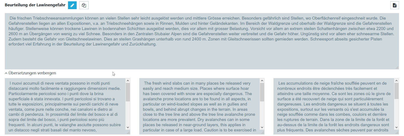
The phrase catalog is a fully automated translation system developed specially for avalanche forecasts by the WSL Institute for Snow and Avalanche Research SLF in Davos.

It is based on a complex catalog of pre-defined sets of words which together build a vast variety of sentences and then are translated into all required languages. When an avalanche forecast is generated, the descriptions of avalanche danger and snowpack analysis are not written freely, but combined like a linguistic puzzle consisting of pre-defined pieces, so that it is immediately available in all three languages. The point of departure, i.e. original language, can be German, as is the case in Tirol and South Tirol, or also Italian, as is the case in South Tirol and Trentino.


Through the permutations of linguistic building blocks, vast contents stand at the ready and can be combined to describe each and every situation precisely.


The phrase catalog enables warning services to generate a translation of avalanche danger assessment and snowpack analysis into German, Italian, English and French automatically.


Since Germanic and Romance languages have quite different grammar, there are built-in limitations to automated translations. The result is generally shorter and simpler sentences which might in some cases sound unusual or repetitive. What is more important, however, is that the information is presented clearly and understandably in all the required languages.


With the help of the phrase catalog and the automated translations connected to it, the avalanche forecaster is directly and immediately present for all readers in all requisite languages in the published report.


Conclusion


The new Avalanche Report in Euregio South Tirol-Tirol-Trentino is no longer written freely by a translator, but rather, assembled automatically by a complex catalog of highly varied sentences which produce countless combinations and which at the push of a button can then appear in German, Italian and English.


Using the phrase catalog demands a big transformation of the avalanche forecasters who stand on the front line. Yet the advantage of the Avalanche Report - that up-do-date versions are always available in three languages - have higher priority.
  

This new system was made possible by the successful collaboration with our colleagues at the avalanche warning service at the WSL Institute for Snow and Avalanche Research SLF in Davos. We extend a deep vote of thanks for their cooperative assistance.

Friday, 8 February 2019

Weak old-snow layers demand caution. Gliding snow increasing.

Current situation

Weak layers in the old snow are currently the main problem for winter sports in Tirol’s mountains.

In East Tirol, separate from the Main Alpine Ridge, the old-snow problem is striking. Due to the shallow snowpack at the end of January, markedly weak layers formed near ground level consisting of faceted snow crystals and depth hoar, and were covered over by fresh snow last week. Between about 1600  m and 2600 m, these weak layers can, in places, be triggered by minimum additional loading, e.g. the weight of one sole skier. Most critical are W-N-E aspects. Due to the depth of the fresh snow, avalanches which fracture in the weak old snow fundment can grow to large size.

In addition, in far-reaching parts of Tirol on south-facing slopes (SE-S-SW) in a narrow altitude band of about 2300-2600 m, we see a weak layer of faceted crystals which developed around a melt-freeze crust in mid-January. In the last few days we have had numerous reports of settling noises and avalanches (see blog of 04.02.) connected to this layer. Prior to the most recent snowfall, this weak layer was quite superficial. In regions where snowfall was heavier, and on slopes which were starkly wind-loaded, the characteristics of the slab, from the point of view of skiers, are less favourable: fractures can propagate far more easily and avalanches can grow to greater magnitude. In East Tirol, this weak layer is part of the weak old-snow fundament.

Snow profile from the borderline Sextner Dolomites from 05.02.2019. SW; 2090m; 34 degrees. In central East Tirol and Dolomites, the fresh snow from last week covers a weak snowpack base. The profile shows depth hoar near the ground and the melt-freeze crust above that, with faceted crystals from mid-January. (©Lukas Rastner; Sarah Graf).


Snow profile in eastern Verwall Massif (Madlein). SW; 2550m; 43 degrees. Weak layers for potential slab avalanches are found near the upper surface above and below melt-freeze crusts. The snowpack layering beneath that is very stable. (©LWD Tirol).


In the snow profile depicted above, a stability test provoked a fracture (ECTP2) above the melt-freeze crust from 16 January. (photo: 06.02.2019).


The weak layer from mid-January led to numerous naturally triggered avalanches during the precipitation last weekend on south-facing slopes between about 2300 and 2600 m. (photo: 06.02.2019).

In the Zillertal Alps, Tux Alps and central Stubai Alps a fracture down to more deeply embedded layers of the old snow is still conceivable. Namely, on very steep, shady slopes between about 2300 and 2600 m. It is likely that only large additional loading will trigger one. The avalanche prone locations occur relatively seldom.

Old-snow problems are always treacherous. They lurk inside the snowpack, making avalanche prone locations unrecognizable for backcountry skiers and freeriders. When aspects and altitude zones are pointed out in the Avalanche Bulletin in this connection, we recommend a defensive route selection. Large, steep slopes should be avoided. 

The current warm temperatures, which are expected to persist through Sunday (see “Outlook”), will also bring about heightened gliding-snow activity. Due to the depth of the snowpack all the way down to low altitudes, glide-snow avalanches can attain great magnitude. The rule of thumb is: circumvent all zones below glide-snow cracks. 

Winters with lots of snow mean high gliding-snow activity. (photo: 06.02.2019).

Positive:

In far reaching parts of North Tirol, quite good backcountry touring conditions currently prevail. On south-facing slopes the snow has been strongly affected by the sunshine. On north-facing slopes, however, the loose fresh snow which fell during the cold front on Sunday, 03.02, can be enjoyed to the hilt. The wide-ranging snowdrift accumulations of last week have bonded well with the old snowpack and are unlikely to trigger. In isolated cases, trigger-sensitive snowdrift accumulations are found on shady slopes adjacent to ridgelines at high and high alpine altitudes, but they are generally small.


Fabulous powder snow on north-facing slopes, as here near the Zittauer Refuge in the Zillertal Alps.  (photo: 05.02.2019).


Surface hoar formed on the snowpack surface during the clear, cold nights. Whereas the sun has more or less decimated this on south-facing slopes, on shady slopes they constitute a weak layer for future snowfall. (photo: 05.02.2019).
  
In northern East Tirol (above, Venediger Massif) winds were strong in recent days and heavily impacted the snowpack surface. (photo: 06.02.2019).


Outlook

In the early morning hours of Friday, 08.02, a weak cold front will reach us in whose wake a few centimeters of fresh snow are expected in the northern regions above 800-1200 m. Winds will increase somewhat, thus, fresh snowdrift accumulations will be generated, particularly on shady ridgeline slopes. They will be small but easy to trigger, in some places deposited on top of light-fluffy snow or surface hoar. The avalanche prone locations will be easy to recognize.

On Friday, snowdrift accumulations will form particularly near ridgelines, most of them small but easily triggered.

Between Friday, 08.02 and Sunday, 10.02, sunshine and cloudiness will alternate. It will remain relatively mild for this juncture of the season. This intermediate warm period will have a positive effect of stabilizing the snowpack on south-facing slopes: the trigger sensitivity of the weak layer in North Tirol will decrease somewhat due to the effects of warmth and solar radiation. On the other hand, gliding snow activity on steep, grass-covered slopes will increase.

Gliding snow activity will be heightened over the next few days. Gartalm, eastern Tux Alps. (photo: 06.02.2019).

On Sunday night, a weather perturbance is anticipated which will bring precipitation, lower temperatures and strong-velocity NW winds. New snowdrift accumulations will be generated, avalanche danger will increase.

The old-snow problem will persist, particularly in East Tirol.

Through Sunday, 10.02.2019, it will remain unseasonably mild. A weather perturbance will follow, bringing lower temperatures and precipitation. (©meteoblue).

On Sunday night, some fresh snow is expected throughout Tirol.

Tuesday, 5 February 2019

Numerous avalanches in Tirol exhort caution, esp. in central + southern East Tirol

Numerous avalanches

During the last few days, numerous avalanches in Tirol have been registered. These were naturally triggered releases in the regions where snowfall has been heaviest, on the one hand; on the other, avalanches triggered by skiers and freeriders. To date, no one has suffered injuries.

In the interim, the phase of naturally triggered slab avalanches has more or less passed. And precisely for that reason, it is important to remind skiers and freeriders that the situation is still quite dangerous, particularly in the central and southern parts of East Tirol, where a striking old-snow problem threatens.

Avalanche danger map in Avalanche Bulletin of 05.02.2019: high danger for skiers in furthermost south

Due to the old-snow problem, slab avalanches can fracture across wide areas and grow to dangerously large size around all those engaged in winter sports. Near the Bösen Weibeles in East Tirol, one group of skiers had incredible luck. By a hair, they missed being swept along. Good luck and perfectly functioning rescue action of group members also led to a fortunate conclusion in Hochfügen in the Tux Alps when someone was completely buried in snow masses.

Photo of an avalanche below the Pfaffenbichl in Hochfügen, made available to us be the Alpine Police: north, about 2300 m, 35-40 degrees. The slab released when two persons were traversing the slope. A person who was totally buried in snow masses was found and rescued. (photo: 02.02.2019)

Avalanche triggered on Hohe Mut South, in rear Ötztal (photo: 02.02.2019)

Slab avalanches on Vennspitze in the Zillertal Alps. North, about 35 degrees, about 2300 m, no one buried.  (photo: 04.02.2019)

In North Tirol, additional avalanches released today, 04.02.2019, in the uppermost snowdrift layers. The avalanches were generally small-to-medium sized, frequently triggering on south-facing slopes at 2100-2600 m. This can probably be attributed to the superficial weak layer of faceted crystals beneath a melt-freeze crust described in the last blog entry.

Furthermore, numerous reports of shooting cracks and settling noises have been reported over the last few days, in North Tirol their frequency is decreasing.

Shooting cracks near Salfeins in the northern Stubai Alps (photo: 02.02.2019)

The loosely-bonded upper snow layer frequently proves to be treacherous, since there was no wind in many places as the last phase of snowfall came to an end. Thus, the previously accumulated snowdrifts couldn’t be recognized (as easily).

Loosely-bonded snowpack surface (starting today, more loose-snow avalanches) atop a harshly wind-impacted snowpack surface near Schartenkogel in the Tux Alps  (photo: 04.02.2019)

For a better grasp of the critical situation prevailing in far-reaching parts of East Tirol, here is a...

Short review

The forecasts of ZAMG Weather Service were perfect once again. The southern part of East Tirol got most of the precipitation. Porzehütte station at 1935 m won the prize, with about 150 mm of precipitation.

Heavy snowfall in southern East Tirol

Southern East Tirol in winter garb: view of Lienz  (photo: 03.02.2019)

A decisive factor apart from fresh snow: fluctuating temperatures, plus storm-strength winds from varying directions.

Naturally triggered avalanches started to trigger rather quickly after precipitation set in. This was primarily due to the poor snowpack layering. Strong winds and rising temperatures during the snowfall also reinforced the dangerous situation.

Wide-area avalanches were frequent in southern East Tirol.  (photo: 02.02.2019)

Wide-area avalanches were frequent in southern East Tirol.  (photo: 04.02.2019)

A similar picture: Schleinitz near the Lienz Basin (photo: 04.02.2019)

When winds shifted to northerly, the next climax of avalanche activity was reached, namely, in the afternoon on 02.02.2019 and during the night.

What remains of this naturally triggered avalanche activity are the glide-snow avalanches on grass-covered slope. These are utterly unpredictable and will assuredly increase in the coming days as temperatures rise, particularly in North Tirol and East Tirol.

Much experience, much restraint called for in outlying terrain, especially in East Tirol

For backcountry skiing and freeriding tours, extensive experience in assessing avalanche risks on-site is called for...and a high degree of restraint, particularly in East Tirol. We exhort all skiers and freeriders to control their urges, restrain themselves! Caution is also urged due to possible remote triggerings in flattish terrain.

In North Tirol, the focus should be placed first and foremost on the recently generated snowdrift accumulations. Avalanche prone locations are found increasingly in terrain adjacent to ridgelines in all aspects, but also on very steep to extremely steep south-facing slopes at 2100-2600 m.

Thursday, 31 January 2019

Huge snow masses in the south generating sharp rise in avalanche danger

Current situation and outlook

Lots of snow in the south

Following a week of highly variable conditions with some snowfall, sunshine, varying wind impact and low temperatures, it’s time to concentrate on the forecasts of the ZAMG Weather Service for the coming days: Tirol will increasingly be caught in the grips of a southerly airstream. Large amounts of precipitation in southern regions and strong to storm-strength southerly winds can be expected.

In southern regions, immense precipitation is anticipated.

Winds have already shifted to some extent, are blowing at strong-to-storm strength in the classic foehn lanes.

For that reason, a warning of heavy snowfall in Tirol’s mountains between Friday, 01.02 at 9:00 am and Saturday 02.02 at 6:00 pm was published by the ZAMG Weather Service.

“The axis of the precipitation will be all of East Tirol and the Zillertal Alps, the focal point is in the mountains of Defereggen, Carnic Ridge, Lienz Dolomites and Schober group. In the East Tirolean Gailtal and bordering Lesachtal, 100-150 cm of fresh snow is expected; in Hohe Tauern and Zillertal Alps 75-100 cm; and between the Brenner mountains and the rear Ötztal 50-75 cm. According to current forecasts, the snowfall level will be at low lying areas in East Tirol throughout the major period of precipitation until Saturday afternoon. It is likely that between 800 and 1500-1800 m, isothermic conditions of 0 degrees will prevail. Wet snow in low lying areas will be the consequence. On Saturday night, the precipitation will calm significantly, and subsequently temperatures will drop measurably.”

Prior to massive precipitation, it is always important to have a look at (and inside) the snowpack. The distribution of snow depths in Tirol is subject to a striking north-south curve: lots of snow in the north, (very) little in the south.

Analysis of the overall snow depths in Tirol: in the central and southern parts of East Tirol there has been very little snow to date. As of tomorrow, 01.02.2019, that is where the brunt of the snowfall is expected.

If you look at the snowpack structure, a marked north-south curve jumps into view. In the northern regions, a generally densely-compacted snowpack is prevalent, the weak layers “only” on the surface. In the southern regions, on the other hand, there are several potential weak layers for slab avalanches inside the shallow snowpack.

Snow profile Thurntaler - Unterwalder Alm on 26.01.2019. NE; 2200 m; 35 degrees. The arrows point to the most significant weak layers in the snowpack: depth hoar lies embedded between hard crusts. Near to the upper surface there is loosely-bonded decomposed snow and surface hoar.  (profile: Bernhard Grüner)

Snow profile in the eastern Deferegger Alps (Blitz Schupfe); south, 2200 m; 31 degrees. The faceted crystals between crusts are relatively well bonded here. A stability test showed no fracture. Only avalanches close to the uppermost surface are likely here. (profile: Daniel Kleinlercher on 24.01.2019)

View into the snowpack near Golzentipp in the Lienz Dolomites region: surface hoar atop a thin mass of fresh snow, beneath that a melt-freeze crust, beneath that faceted, loosely-bonded crystals: surface hoar and faceted crystals constitute two potential weak layers for slab avalanches in case of further loading. (photo: 27.01.2019)

Snow profile on Carnic Ridge in the Lienz Dolomites region. Easily distinguishable through colors: fresh snow and beneath that, weak old snow.  (photo: 31.01.2019)

Old-snow problem in central and southern East Tirol

Particularly in the central and eastern parts of East Tirol, we are faced with a quite widespread old-snow problem at various altitudes and in various aspects. As potential weak layers, loosely-bonded, faceted crystals and depth hoar are the foremost candidates. In the region of the Lienz Dolomites, the old-snow problem begins on shady slopes above approximately 1200 m, in eastern and western aspects above about 1600 m, in southern aspects above about 2000 m.

In the central part of East Tirol, the most endangered area lies between about 1800 and 2500 m in W/N/E aspects. (Special caution is urged also at the edges of forested areas below 1800 m.) On south-facing slopes, in addition, beneath a thin, surficial melt-freeze crust which formed in mid-January, a thin, faceted weak layer formed within a quite narrow altitude band on very steep south-facing slopes at about 2300-2500 m. (The latter was also observed in other parts of Tirol.)

Observed with increasing frequency: due to the danger pattern cold-on-warm (dm.4) a loose layer of faceted crystals has been forming beneath a melt-freeze crust since mid-January at altitudes between about 2300 and 2500 m on very steep south-facing slopes.  (In this profile in the northern Stubai Alps at 2730 m, south, 38 degrees, no fracture has yet propagated inside the faceted layer.)  (profile: Lukas Ruetz am 25.01.2019)

In addition, the snowpack surface, except on very steep, sunny or wind-impacted slopes, largely consists of loosely-bonded, cold fresh snow. There is also widespread covered surface hoar, excluding in heavily wind-impacted terrain where it has been windswept.

In every place where the snowpack surface was not impacted by the wind or by the sun, there is cold, loosely-bonded powder snow or, as seen in this photo, surface hoar. The surface hoar has been covered by some fresh snow in many places. (photo: 25.01.2019)

Fresh snow from the beginning of the week (27-28 January) cloaks central and southern East Tirol in wintery garb.  (photo: 29.01.2019) 

Weak layers near the surface further to the north

If we cast a glance further north, we observe  a quite favourably layered old snowpack over widespread areas. (Only in the central Stubai Alps are there persistent deep weak layers in some places. In the interim, however, they are probably triggerable only in highly unfavourable conditions.) Nevertheless, in the northern regions there are weak layers near the upper surface in the form of cold, loosely-bonded powder snow, surface hoar or light-fluffy snow. Due to the wind impact, which occurred often during the week, at least at high altitudes, this snow was transported, so that area-wide, cohesive, loosely-bonded layers become more and more seldom with ascending altitude. This means that atop these weak layers, large-scale slab avalanches will be the exception rather than the rule. (Caveat: regions which have been wind-protected until now, e.g. sparsely wooded zones, are excluded.)

Loosely-bonded, cold snowpack surface in the southern Ötztal Alps  (photo: 29.01.2019)

A loosely structured snowpack surface in Kelchsau in the Kitzbühel Alps  (photo: 27.01.2019)

Consequences

Fresh snow accompanied by strong-to-stormy winds transporting the snow will burden the snowpack measurably. Accordingly, avalanche danger will increase rapidly in the regions where precipitation is heaviest and will increase to “high” at latest on Saturday, 2 February. We expect numerous naturally triggered avalanches. These will be most frequent in the regions which have remained wind-protected to date, e.g. in sparsely wooded areas at the timberline or cliff bowls which have been protected from wind until now. The largest avalanches, comparatively, will take place in NW to N to NE aspects. Due to the shallow snow depths overall, extremely large-sized avalanches are not expected.

View from Golzentipp towards the south, the ridge on the Italian border and the region where the greatest amounts of snowfall are anticipated in coming days. We expect not only high activity of naturally triggered slab avalanche, but also the largest-sized avalanches. (photo 27.01.2019)

Since the snowfall will be moist up to approximately 1800 m, we will also be confronted with increasingly frequent glide-snow avalanches. These could glide over steep, grass-covered slopes and put exposed transportation routes at risk in some spots.

Glide-snow avalanches on steep, grassy slopes, particularly wherever there has been heavy snowfall and the snow is wet or where there has been heavy rainfall into the snowpack. Zillertal. (photo: 19.01.2019)

Caution is also urged towards trees which fall over due to the burden of snow on the branches, or branches which break off under the weight of snow.

Apart from the danger of avalanches in the regions where snowfall has recently been heavy, this is also a risk... Stubaital  (photo: 30.01.2019)

For participants in winter sports, extremely treacherous and highly dangerous conditions prevail in the regions where snowfall has recently been heavy.

Further to the north, where there is less snowfall, restraint is also urged. Snowdrift accumulations continue to be highly trigger-sensitive, can be unleashed by one sole skier. The above-described area-wide distribution of a weak layer near the upper surface is here the case with regard to wind impact to date.

Strong to storm-strength winds will also transport much snow over the next few days, generating some dangerous snowdrift accumulations. Tux Alps  (photo: 27.01.2019)

In the Kitzbühel Alps over the last few days, several avalanches were triggered by skiers in the weak layers near the upper surface, e.g. surface hoar.  (photo: 27.01.2019)

Shooting cracks, as in photo in the Tux Alps, indicate a snowpack which is prone to triggering: snowdrifts atop surface hoar or loosely-bonded, cold powder.  (photo: 25.01.2019)

Review

This last week 24.01.-31.01.2019

As already mentioned, this last week has been highly varied. Whoever planned the tour carefully was able to enjoy lots of sunshine and rather good conditions, depending on selected terrain.

In a nutshell: variable. Station Puitegg in the Mieminger Massif

Repeated bouts of snowfall in Tirol

Unexpected masses of snow (up to 60 cm) over limited terrain near Kelmen in Ausserfern. (a precipitation cell of just a few kilometers probably due to a convergence) (photo: 29.01.2019)

This last month: January 2019

The month of January 2019 will go down in history with a few medals, according to the ZAMG Weather Service:

Northern regions registered above-average amounts of snowfall (about 150% of the average). It was one of the ten heaviest-precipitation months of January in the last 160 years. The 15-day overall sum of fresh snow between 1 and 15 January was record-breaking in some places, e.g. amounted to 451 cm in Hochfilzen. This corresponds to an event which takes place even more seldom than once in 100 years. In the south (southern regions of East Tirol) on the other hand, only 20% of the mean amount of snowfall was registered this month.

Precipitation in January 2019: comparison with precipitation average 1981-2010. One hundred percent corresponds to the average. Evaluation with SPARTACUS data through 20.01.2019.  (source: ZAMG)

Viewing temperatures, it was also a cold January. In the mountains it was the coldest January for more than 30 years. The lowest temperature measured in Tirol was on 11.01.2019: -25.5°C at 3437 m on the high Brunnekogel of the Pitztal Glacier.

Temperatures January 2019: divergencies from average temperature 1981-2010. Evaluation with SPARTACUS data through 29.01.2019  (source: ZAMG)