Friday, 24 February 2023

Much too little snow for this juncture of the season – Persistent weak layer esp. on very steep shady slopes near ridgelines – Minor snowdrift problem on the weekend

 In short:


The lack of precipitation this winter is quite striking in the snow cover. For this juncture of the season there is much too little snow on the ground, not only here in Tirol but in far-reaching parts of the Alps. See also the Blog of our colleagues in Switzerland.

Avalanche danger levels are moderate, particularly on the Main Alpine Ridge and a little north of there above about 2200m. That is because of isolated avalanche prone locations where winter sports enthusiasts can still trigger releases. Please refer to our last Blog. 

On the weekend some fresh snow will be added to it. Avalanche danger will increase somewhat from region to region. Above the timberline, approximately, freshly generated snowdrift accumulations require caution.


(Much too) little snow

For the next few days, a bit of snowfall is in view but that does not much change the overall snow picture, i.e. dearth of snow. The puny snow depths can most easily be appreciated in a comparison of wetcam photos and with long-term records of our observers:


Die Grafik zeigt die von unseren Beobachtern auf der Nordkette gemessenen Schneehöhen seit 1973. Oberer Bereich: bisherige Maxima - Unterer Bereich: bisherige Minima - Graue Linie: Mittelwert - Linie in magenta: Schneehöhe des Winters
The graph shows snow depths measured by observers on the Northern Massif since 1973. Upper border: maxima till now. Lower border: minima till now. Gray line: medium value. Line in magenta: snow depths this winter


Schneehöhe auf der Seegrube oberhalb von Innsbruck mit Blick ins Wipptal (22.02.2023)
Snow depths on the Seegrube above Innsbruck looking towards Wipptal (22.02.2023)


Vergleichsfoto vom 21.02.2019
For comparison, a photo from 21.02.2019


Ähnlich in weiten Teilen Tirols: An Sonnenhängen findet man bis in größere Höhen kaum mehr eine zusammenhängende Schneedecke (Foto: 21.02.2023; (c) Stefan Zangerl)
Similar pictures throughout Tirol: on sunny slopes, hardly a cohesive snowpack up to high altitudes.
(photo: 21.02.2023; (c) Stefan Zangerl)


Die Schneearmut macht sich auch auf den Gletschern bemerkbar, wo für die Jahreszeit eine überdurchschnittlich hohe Spaltensturzgefahr besteht - Gurgler Gruppe. (Foto: 21.02.2023)
A lack of snow is also noticeable on the glaciers, where a very high danger of falling into crevices threatens for this juncture of the season.  Gurgler Massif  (Foto: 21.02.2023)


Persistent weak layer in isolated places, esp. near ridgelines on very steep shady slopes

In the interim, quite favourable conditions reign, as far as avalanche danger is concerned. However, there are still isolated danger zones where slab avalanches can be triggered. These spots are found especially on very steep shady ridgeline slopes above about 2200m. Avalanches can be triggered especially wherever there have been only few winter sports enthusiasts this year, and in transition zones from shallow to deep snow. For further details, please consult our last Blog.  


Schneeprofil im Bereich einer kürzlich von Wintersportlern ausgelösten Schneebrettlawine in den Nördlichen Zillertaler Alpen (21.02.2023)
Snow profile near a recent slab avalanche triggered by a winter sports enthusiast in northern Zillertal Alps.
 Persistent weak layer.  (21.02.2023)


Outlook: fresh snowfall will lead to a small snowdrift problem

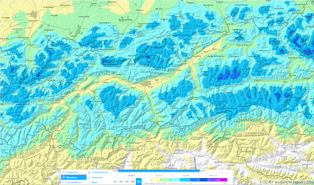
Geosphere Austria weather service forecasts snowfall in the next few days. In general, about 20cm is expected at high altitudes, up to 40cm from place to place. The snowfall will be accompanied by strong-velocity winds, mostly from the west.


72h Neuschneeprognose 24.02.-26.02.2023
72-hr fresh snow forecast 24.02.-26.02.2023

This will lead to a generally minor snowdrift problem above the timberline, which could be somewhat more pronounced in the major areas of precipitation. Caution urged in wind-protected, very steep slopes behind abrupt discontinuities in the terrain.

Fresh snow and freshly generated snowdrifts will be deposited atop a highly diversified snowpack surface:
  • melt-freeze crusts which are more or less capable of bearing loads on steep sunny slopes and shady slopes up to intermediate altitudes;
  • knobby powder in wind-protected shady terrain and at high altitudes in wind-protected flat terrain
  • snowpack surfaces which were recently hit by wet-snow slides
  • snowpack surfaces showing high wind impact at high altitudes
Fresh snow and snowdrifts are expected to bond quite well with the old snowpack. The bonding is least favourable of all, by comparison, where there was knobby powder up to the time of precipitation.


Tragfähige Schmelzkruste im besonnten Gelände in den Alpeiner Bergen (Foto: 16.02.2023)
Melt-freeze crust capable of bearing loads in sunny terrain, Alpeiner mountains (photo: 16.02.2023)


Noppenpulver in der Silvretta (Foto: 21.02.2023)
Knobby powder in the Silvretta (photo: 21.02.2023)


Eine von kleinen Nassschneerutschen beeinflusste Schneeoberfläche. Östliches Karwendel (Foto: 22.02.2023)
Snowpack surface showing impact from a small wet-snow slide. Eastern Karwendel
(photo: 22.02.2023)


Wie vom Fotografen dieses Bildes treffend geschildert: Der Wind lag am vergangenen Wochenende "über Steinverfrachtungsstärke" Region Sellrain-Alpeiner Berge (Foto: 19.02.2023)
As the photographer so aptly put it: Winds last weekend were blowing at “above rock-transport velocity.” Region Sellrain-Alpeiner mountains (photo: 19.02.2023)


Station Nachtweide - Palinkopf in der Silvretta: Windig wars am vergangenen Wochenende. Freitag, 17.02. und Samstag, 18.02. noch vermehrte Durchfeuchtung und dadurch etwas erhöhte Nassschneeaktivität. In Summe etwas wechselhaft mit auch sehr sonnigen Phasen. Die Temperatur geht nun langsam zurück.
Measurement station Nachtweide - Palinkopf in the Silvretta: it was windy last weekend. Friday, 17.02 and Saturday, 18.02, still a thoroughly wet snowpack and thus, heightened wet-snow activity. All in all, variable conditions with sunny intervals, temperatures receding only slowly.


Niederschlags- und Windprognose samt Entwicklung der Schneefallgrenze für eine der prognostiziert niederschlagsstärksten Regionen, den Zentralen Kitzbüheler Alpen.
Precipitation and wind forecasts including changes in snowfall level for the major region of precipitation,  central Kitzbühel Alps.


Temperaturprognose für die kommenden Tage. Es wird kälter, ab Wochenbeginn steigen die Temperaturen wieder.
Temperature forecast for coming days. It will get colder, but temperatures will rise again starting next week.


For a brief spell: loose-snow avalanches right after the snowfall

When the forecast snowfall comes to an end and solar radiation returns, numerous loose-snow avalanches can be expected on extremely steep slopes. In very isolated cases, small naturally triggered slab avalanches are conceiveable in the major areas of precipitation, particularly on very steep slopes where there are freshly generated snowdrift accumulations plus massive solar radiation with higher daytime temperatures. Those moments of danger are expected to arrive...and then swiftly depart.

Wednesday, 22 February 2023

Persistently treacherous – persistent weak layer

 To start off: 

The persistent weak layer which has persisted for a long period is still of significance for avalanche releases in isolated cases. This was amply demonstrated last week by several avalanche triggerings in which persons were involved.

  • Wednesday, 15.02.2023: negative avalanche Gstreinjöchl, Ridnaun Massif
  • Thursday, 16.02.2023: negative avalanche Pfaffenbichl, western Tux Alps
  • Saturday, 18.02.2023: two negative avalanches Hohe Warte (Schmirn), northern Zillertal Alps
  • Saturday, 18.02.2023: 1 person injured, Hohe Warte (Schmirn), northern Zillertal Alps
  • Sunday, 19.02.2023: negative avalanche Gammerspitze, northern Zillertal Alps
  • Sunday, 19.02.2023: 1 person injured, Geraer Hütte, northern Zillertal Alps
  • Tuesday, 21.02.2023: negative avalanche Hohe Warte (Schmirn), northern Zillertal Alps
What stands out is the conglomeration of avalanche releases reported in the northern Zillertal Alps, four of them near the Hohe Warte. The avalanches were loosed at 2200 - 2600m altitude, mostly on north-facing slopes. East-facing and west-facing slopes are equally endangered. The avalanches were all unleashed in transition zones from shallow to deep snow in very steep to extremely steep terrain.


Danger zones are...where the best skiing is

What is so treacherous in the present situation is the fact that the avalanche prone locations are precisely where the best skiing is to be found. In wind-protected zones at this altitiude and in this aspect there is frequently “knobby powder” to be found, in other words, beautifully skiable, expansively metamorphosed, loose snow. Below that, there still is a “slab” in the relevant places from the last round of precipitation at the beginning of February. Thus, you don’t break through to the ground, as is often the case.

Treacherous, because there are only few danger zones...and they’re not visible to the naked eye

Throughout Tirol, similar such steep slopes in the relevant altitudes and aspect are currently being skied on, without avalanches being triggered. That underscores the low frequency of danger zones in general. Nevertheless - and this is the crucial point - the weak layers lurking inside the snow cover can still be triggered by winter sports enthusiasts in unfavourable circumstances. The steeper the slope and the less-tracked it is this winter, the more frequently this occurs. Caution: terrain which was tracked only after the bout of precipitation at the beginning of February is also endangered. (Tracks don’t mean that this is safer. With a bit of bad luck, you touch a hot spot.)


Lawinenabgänge Hohe Warte: violett: Anfang Februar; magenta: Lawinen vom 18.02. (die längste davon war jene mit der verletzten Person) rot: Lawine vom 21.02.2023; 2500m, NO (Foto: 21.02.2023)
Avalanches Hohe Warte: violet: beginning of February; magenta: avalanches on 18.02 (the longest one was where someone was injured, ending up in the lowermost avalanche zone) red: avalanche on 21.02.2023; 2500m, NE (photo: 21.02.2023)


Lawinenabgänge Gampesspitze (links) und Gammerspitze (rechts) jeweils mit Personenbeteiligung, jeweils unverletzt, 2500m, Nord (Foto: 21.02.2023)
Avalanches Gampesspitz (left) and Gammerspitze (right) each involving persons, no injuries, 2500m, N (photo: 21.02.2023)


Lawine unterhalb der Geraer Hütte: 2200m, West (Foto: 21.02.2023)
Avalanche below Geraer Hütte: 2200m, West (photo: 21.02.2023)


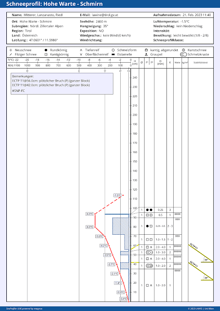
Bezeichnendes Profil für noch vorhandene Problembereiche: Oberflächennah ist das Brett gerade noch ausreichend ausgeprägt (90-70cm); darunter die noch störanfälligen Schwachschichten. Hohe Warte, 2460m, NO, 35° (Weitere Profile, wie immer unter www.lawis.at
Instructive profile for still existing problem zones: near-surface slab just sufficiently pronounced (90-70cm); beneath that, the still prone-to-triggering weak layers. Hohe Warte, 2460m, NE, 35°
(for additional profiles, as always see www.lawis.at 

Friday, 17 February 2023

Quite good conditions in general. Slight loss of firmness in places due to solar radiation and daytime warming

To sum it up: Danger zones especially in little-tracked shady very steep terrain

During the last few days, Avalanche Headquarters Tirol received only isolated reports of avalanches involving persons (no injuries). Moreover, most snowpack analysis in the interim demonstrates a lack of tension inside the snowpack. Thus, we can assume there are only limited avalanche prone locations in open terrain where slab avalanches can now be triggered, particularly in shady, very steep terrain which has been not much tracked over the winter. On sunny slopes we assume very isolated danger zones for dry-snow slab avalanches around 2500m altitude.


On sunny slopes: high caution if they are wet

In the last few days avalanche danger levels increased slightly. In extremely steep sunny terrain we observed isolated moist loose-snow slides. On steep grass-covered slopes, somewhat more frequent glide-snow slides and small glide-snow avalanches occurred.


Die roten Pfeile zeigen auf kürzlich abgegangene Lockerschneerutsche. Die blaue Ellipse umrahmt einen Gleitschneerutsch, die Ellipse in magenta zeigt eine ca. 10 Tage alte Schneebrettlawine. Westliche Tuxer Alpen. (Foto: Hubert Gogl, 15.02.2023)
Red arrows point to recent loose-snow slides. Blue ellipse encircles a glide-snow slide, the magenta ellipse a slab avalanche about 10 days prior. Western Tux Alps. (photo: Hubert Gogl, 15.02.2023) 


Gleitschneemäuler in den Östlichen Lechtaler Alpen (Foto: 15.02.2023)
Glide-cracks in eastern Lechtal Alps (photo: 15.02.2023)

Firn snow

Following nights of clear skies, a melt-freeze crust capable of bearing loads forms on very steep sunny slopes, especially at intermediate altitudes. Due to the dry air, this is slower to soften up during the daytime. If you planned your time carefully, pure firn-snow enjoyments awaited. Weather conditions will now become less stable, firn snow will be found more seldom.


Firnabfahrt in den  Östlichen Lechtaler Alpen (Foto: 15.02.2023)
Descent through firn snow in eastern Lechtal Alps (photo: 15.02.2023)


Knobby powder on shady slopes

Away from sunny slopes in a few wind-impacted zones you can find a loosely-packed, roughed-up snowpack surface. We refer to this as “knobby powder” which is excellent to ski through. (Caution: sharks are a threat - rocks just beneath the surface.)


Im Noppenpulver lassen sich schöne Schwünge ziehen (Foto: 12.02.2023)
In knobby powder your ski turns are more elegant. (photo: 12.02.2023)

 
Weather development

According to Geosphere Austria (formerly ZAMG), conditions are becoming more variable, the air masses more moist. Nocturnal longwave outgoing radiation will decrease. Due to more shade during the daytime hours there will also be less energy penetrating the snowpack, unless there is more sunshine than expected. In that case, due to heightened air moisture and solar radiation more energy can penetrate the snow cover. For that reason, it’s important to keep your eye on the degree to which the snowpack becomes moist or wet, since if water seeps for the first time down to the often encrusted layer of faceted crystals at about mid-level in the snowpack, it will lead to more loss of firmness and heightened likelihood of slab avalanches triggering. The process is accelerated by the shallowness of the snowpack for this juncture of the season.


Additional information


Immer noch liegt für die Jahreszeit vielerorts viel zu wenig Schnee. Die obere Grafik zeigt die bisher gemessenen Maxima und Minima, sowie den Mittelwert seit 1960. Magenta: Aktueller Winter
Still too little snow for this juncture of the season. Top graph: maxima and minima to date, and middle value since 1960. Magenta: this winter


Das Wetter der vergangenen Woche: Kurze Eintrübung ab Samstag, 11.02. nachmittags, sonst meist prächtig schönes Winterwetter. Temperatur geht wieder leicht zurück
Last week’s weather: brief period of gray skies starting Saturday, 11.02 afternoon; otherwise generally splendid wintery weather. Temperatures dropping slightly.


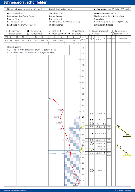
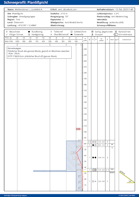
Temperaturkurven bei Schneeprofilen geben Aufschluss über die Temperaturreserven der Schneedecke. Je näher bei 0°C, desto rascher kann eindringendes Wasser in tiefere Schichten eindringen und die Schneedecke schwächen.
Temperature curves in snow profiles reveal the temperature reserves inside the snowpack. The closer we get to 0°C, the quicker water seepage can penetrate to the deeper layers and weaken the snowpack.

Monday, 13 February 2023

Persistent weak layer in some places – Slight daytime danger cycle for avalanche risks due to solar radiation and rising temperatures

Before all else: Besides persistent weak layer problem, daytime loss of snowpack-surface firmness


Last week’s biggest threat, the persistent weak layer, remains with us above 2000m. In the interim, frequency of avalanche prone locations where slabs can be triggered has diminished significantly. Avalanches are mostly triggerable on very steep slopes in transition zones from shallow to deep snow. Therefore: restraint and caution in untracked, very steep terrain is imperative.

To this risk must now be added the increasing degree of snowpack wetness during the course of the day. On very steep to extremely steep sunny slopes, the snowpack can forfeit its firmness thereby. But if backcountry tourers plan their time carefully, the reward at intermediate altitudes will be great firn snow.


Forfeiting firmness of snowpack due to solar radiation and higher temperatures

Splendid winter weather including higher temperatures and intensive solar radiation has its impact: at very least the near-surface part of the snowpack becomes thoroughly wet. Where the snow is shallow, wetness penetrates much deeper. Water seepage in the snowpack generates a loss of overall firmness. That means the melt-freeze crust which formed during the night (and was often capable of bearing loads) gets softened up. 

Three scenarios are conceivable:
  • On extremely steep slopes, moist or wet loose-snow avalanches trigger.
  • These loose-snow avalanches burden the snowpack on their plummet path so much that slab avalanches are triggered.
  • Water seeps down to the faceted layer which caused the persistent-weak-layer problem (beneath a thin melt-freeze crust). Thereby the weak layer loses its firmness. The likelihood of a slab avalanche triggering thereby increases. This scenario is especially applicable to extremely steep S/SE to S to S/SW facing slopes where the snow is shallow at intermediate altitudes.

Die aktuelle Situation


Steigende Temperaturen. Steigende Schneeoberflächentemperaturen mit entsprechendem Tagesgang.
Rising temperatures. Rising snowpack-surface temperatures and the corresponding daytime danger cycle.  


The curve of snowpack-surface temperature is becoming flatter at the measurement stations. That demands heightened attentiveness to the increasing wetness of the snowpack.


Avalanche Kellerjoch on 12.02.2023

Yesterday (12.02.2023) an avalanche near the Kellerjoch in the direction of Naunzalm was reported. Since it was not certain if persons were buried in snow, a search operation was initiated that was hampered by subsequent avalanches. In the end, the all-clear signal could be given, no one was buried in the snow.

The analysis of this avalanche proved to be highly interesting, since we had no reason to expect a naturally triggered slab avalanche based on available data. However, as is so often the case, the explanation was simple...it lies in the devilish details. On Saturday, cloudbanks which moved in during the afternoon caused an intense moistening of the snowpack. We assumed that at least the latter part of the night would have clear skies, but that was definitely not what happened in the Lower Inn Valley. In the accident zone, nocturnal skies were heavily overcast with only tiny gaps. Thus, the prerequisites for longwave outgoing radiation and re-firming up of the superficially moistened snowpack were lacking. Solar radiation and higher daytime temperatures then generated a thoroughly wet snowpack, much wetter than anticipated. (By comparison, today on 13.02.2023 we have a better starting situation due to very clear nighttime skies and highly effective outgoing radiation.)


Lawinenabgänge Kellerjoch vom 12.02.2023. Extrem steil südseitig. Anrissgebeit um 2100m.
Avalanche Kellerjoch on 12.02.2023. Extremely steep south-facing slope. Fracture at 2100m.


Webcambild Bremerhütte Richtung Osten. Samstag nachmittags, als die Wolkendecke kurzfristig am dichtesten war. Gebietsweise bildete sich aufgrund dieser Wolkenbedeckung übrigens an der Schneeoberfläche eine dünne Eislamelle (v.a. oberhalb etwa 2500m), während der Nacht vom 11.02. auf den 12.02. zusätlich auch noch Oberflächenreif.
Webcam shot from Bremerhütte towards the east. Saturday afternoon, when clouds were at their heaviest for a brief spell. Incidentally, a thin film of ice formed on the snowpack surface (esp. above 2500m) due to this cloud cover. During the night on 11.02, surface hoar formed on top of that.


Upshot

Please pay close heed to snowpack wetness in the next few days. Only on-site is it possible to determine this.

Apart from that: wherever a melt-freeze crust which is capable of bearing loads has formed during the night, you need to pay close attention to potential risks of taking a fall in steep terrain...otherwise there is awesome firn snow to be enjoyed (with good time planning).


Eines der möglichen Szenarien für die kommenden Tage: Lockerschneelawine löst Schneebrettlawine aus. (Foto: 12.02.2023)
One of the possible scenarios for the next few days: loose-snow avalanche triggers a slab avalanche.
(photo: 12.02.2023)

Friday, 10 February 2023

Analysis of deadly avalanches. Current situation treacherous.

 Avalanche time


The term “avalanche time” has locked a heavy stamp on the education of Austrian mountain and ski guides. It designates the short period in a winter season which bears far higher risks of avalanches. Just such a period was what we had between 3rd and 6th of February. Within that short time, 8 people died in avalanches. (A comparable avalanche period occurred last winter at the same juncture. Between 4th and 5th of February 2022, also 8 persons were killed in avalanches.)


Persistent weak layer: primal cause

To start off: in all the recent avalanches with fatalities the persistent weak layer was the cause. Snowpack analysis on-site or in the immediate vicinity of the accident brought the selfsame picture: a long-enduring weak layer of faceted crystals (sometimes with depth hoar) was found beneath a thin melt-freeze crust. Atop that, usually a pronounced slab from the previous bout of precipitation including transported snow masses.


64 avalanches were reported to Avalanche Headquarters Tirol between 3 and 5 February

Here is an overview of the avalanches reported to headquarters between 3 and 5 February.


Lawinenmeldungen gabs über ganz Tirol verteilt. (Die Karte wurde um den tödlichen Unfall am 06.02. im Wannenkar im Nahbereich der Hohen Wasserfalle ergänzt) 7 Lawinen mit Todesfolge, 15 Lawinen mit Personenbeteiligung, 42 Negativlawinen (Karte: (c) Landeswarnzentrale Tirol)
Reports of avalanches came from all of Tirol (map was extended to include the fatal accident on 6 February in the Wannenkar near the Hohen Wasserfalle) 7 had fatalities, 15 avalanches in which persons were involved, 42 negative avalanches  (map: (c) Landeswarnzentrale Tirol)


Most avalanche investigations made with assistance of state helicopter

Our accident analysis is undertaken with the Alpine Police. The state helicopter assisted us with indispensable service, enabling us to save valuable time during this hectic period.


Der Landeshubschrauber bei der Unfallerhebung am Hohen Aifner (Foto: 05.02.2023)
State helicopter and flight operator in the investigation on Hohen Aifner (photo: 05.02.2023)


Avalanche accident Königstal (Gurgler Massif) on  03.02.2023

Short description

3 persons skied into open terrain from Hochgurgl ski area near the Wurmkogel. Initially they planned to reach Königstal via Kleine Königstal, then ski down to the valley. A later person in the accident previously chose the same route of descent. On a ridge covered by a cornice this person wanted to jump over the ridge and be filmed by an accompanying person. After the jump the person took a fall, which triggered an avalanche, sweeping that person away, burying him quite deep. He did not survive.


Lawinenunfall Königstal vom 03.02.2023. Der Kreis symbolisiert die Verschüttungsstelle. Das Foto wurde zwei Tage nach dem Lawinenunfall aufgenommen. Gut zu erkennen, die aufgrund von Schneefall und Sturm bedingte hohe spontane Lawinenaktivität im Nahbereich der Unfalllawine. Die Lawine löste sich auf 2500m in einem extrem steilen SW-Hang. Die Lawine war ca. 100m breit und 200m lang. (Foto: 05.02.2023)
Avalanche accident Königstal on 03.02.2023. The circle indicates the place of getting buried in snow masses. The photo was taken two days after the accident. The high degree of naturally triggered avalanche activity in the vicinity of the accident due to snowfall and stormy winds is easy to recognize. The avalanche triggered at 2500m on an extremely steep SW slope. It was appx. 100m wide and 200m long.
(photo: 05.02.2023)


Nahaufnahme des Anrissgebietes: Der Pfeil zeigt die Geländekante und die ungefähre Stelle, wo die verunfallte Person in den Hang gesprungen ist. (Foto: 03.02.2023)
Close-up shot of fracture zone: arrow points to the ridge and approximate spot where the person leaped into the slope. (photo: 03.02.2023)


Das Schneeprofil wurde 120m oberhalb des Lawinenanrisses aufgenommen. Die Schwachschicht aus kantigen Kristallen war zwischen zwei Krusten eingebettet - "Krustensandwich" (Profil vom 05.02.2023)
 This snow profile was taken 120m above the avalanche fracture. The weak layer of faceted crystals lay embedded between two crusts - a crust sandwich. (profile from 05.02.2023) 


Avalanche accident Gedrechter (eastern Tux Alps) on 04.02.2023

Short description

A very good skier was descending near the Neuhütten lift north of the Gedrechter with other persons, skied away from the group and came into open ski territory north of a closed ski run. There, a slab released which swept him away and buried him about 2m deep. The avalanche accident occurred when visibility was poor, which explains why the group realized what had happened only after a delay. The buried person was found by means of a beamer and dug out. Their help came too late.


Die Lawine im Nahbereich des Gedrechter. Die Lawine löste sich kammnah in einer Höhe von 2050m in einem extrem steilen NO-Hang. Die Lawine war ca. 120m lang und 60m breit. Kreis: Verschüttungsstelle (Foto: 05.02.2023)
Avalanche near the Gedrechter. It triggered near the ridgeline at an altitude of 2050m on an extremely steep NE-facing slope, was about 120m long and 60m wide. Encircled: the point of burial  (photo: 05.02.2023)


Der obere Bereich des Lawinenanrisses (Foto: 05.02.2023)
Upper zone of avalanche fracture (photo: 05.02.2023)


Interessant an diesem Profil ist die oberflächennahe Ausbildung einer dünnen Schmelzkruste samt kantigen Kristallen. Vermutlich durch gm.4 (kalt auf warm) entstanden. Dort ev. Primärbruch, darunter im Bereich des Krustensandwiches sekundärer Bruch. (Profil vom 05.02.2023)
Interesting aspect of this profile: superficial formation of a thin melt-freeze crust with faceted crystals, presumably formed due to dp.4 (cold on warm). That was possibly the primary fracture, below it near the crust sandwich a secondary fracture. (profile on 05.02.2023)


Avalanche accident Hoher Aifner (Kaunergrat) on 04.02.2023

Brief description

A single backcountry tourer went with his dog onto the Hohen Aifner, a popular backcountry destination. In the descent through extremely steep terrain a slab avalanche released and swept the tourer and dog with it. The dog was able to escape after about 800m. The tourer was completely buried. The dog ran home, members of the family notified a rescue team. On 05.02 the tourer (who had no LVS beamer) was located with a recco sensor from the helicopter. In the search action which followed, the lifeless body was found.


Lawinenabgang Hoher Aifner. Die Person wurde beim Knick im Bereich der Waldgrenze aufgefunden. Die Lawine löste sich in einer Seehöhe von etwa 2700m in einem 40° steilen SO-Hang.
Avalanche Hoher Aifner. The person was found near the timberline in the crease. The avalanche triggered at appx. 2700m, 40° steep gradient on the SE-facing slope.


Im Nahbereich des Anrissgebietes. Der Pfeil zeigt die Einfahrtsspur. (Foto: 05.02.2023)
Near the fracture point. Arrow points to the entry track. (photo: 05.02.2023)


Profilort orographisch links der Unfalllawine. Bei allen Unfällen ein sehr ähnliches Bild. (Profil vom 05.02.2023)
Zone of accident orographically left of the avalanche. For all the accidents the picture was similar. (profile from 05.02.2023)


Avalanche accident Kapall - Törli (western Lechtal Alps)

Brief description

3 freeriders left the St. Anton ski area from Kapall, heading towards Törli-Schöngraben. Before the guided group reached the extremely steep entry into the trench there, a small slab released. The group continued into the extremely steep trench, where an additional avalanche triggered, sweeping two persons with it. One was able to exit the plummet path, made an alarm call and was subsequently brought to safety by a helicopter. Due to the high avalanche danger, the search operation was postponed until the next day. The missing person was then found with an LVS beamer, who died on the spot 3-4 metres deep.


Bei der langgezogenen Lawine in magenta handelt es sich um die Unfalllawine. Die darüber in magenta eingefärbte Lawine war jene, die sich zuvor schon während der Abfahrt der Personen löste. Die in violett eingefärbten Lawinen wurden als Sicherheitsmaßnahme für die Bergung der Opfer gesprengt. Die Lawine löste sich in einer Seehöhe von etwa 2010m in einem O-Hang. Die Breite betrug ca. 30m, die Länge 550m. (Foto: 04.02.2023)
The colored zone is the accident avalanche, the pale-shaded zone the previous release which the descent triggered. The violet-colored avalanches were artificially triggered as safety measure in locating the victims. The avalanche triggered at about 2010m on an east-facing slope. It was about 30m wide, 550m long. (photo: 04.02.2023)


Das Schneeprofil wurde abseits des Lawinenabgangs beim nahe gelegenen Almajurjochs aufgenommen. Das Profil im Anrissbereich wird sehr ähnlich ausgeschaut haben - eine langanhaltende Schwachschicht unterhalb einer dünnen Schmelzkruste (Profil vom 09.02.2023)
This snow profile was taken near Almajurjoch, apart from the avalanche release. The profile in the fracture zone was doubtless very similar - a persistent weak layer beneath a thin melt-freeze crust.
(profile from 09.02.2023)


Avalanche accident Steinermandl (Schober Massif) on 04.02.2023

Brief description

A tractor driver wanted to plow a forest road in Debanttal in the Schober Massif. He initially drove towards the valley via the Debanttal, then on the so-called Stubenweg above it towards Zettersfeld. When the person in the tractor drove into a well-known avalanche zone known as Jasdorfer Lana, a slab triggered at about 700m altitude. It struck the tractor with all its force. The person was hurled out of the vehicle, his lifeless, half-buried body was found during a nocturnal search operation. The tractor was swept along for about 200m and utterly destroyed.


Die rote Linie zeigt die Forststraße. Die Person kam mit ihrem Traktor von rechts her. Der Kreis zeigt den Liegepunkt des völlig zerstörten Traktors. Das Anrissgebiet der Lawine befindet sich auf ca. 2150m. Die Lawine ist im Anrissgebiet um 100m breit und ca. 1000m lang. Die Lawine löste sich in einem extrem steilen NO-Hang. (Foto 05.02.2023)
The red line shows the forest road. The tractor driver approached from the right. The circle indicates the spot where the destroyed tractor came to rest. The fracture zone of the avalanche was at about 2150m, was 100m wide and about 1000m long. The avalanche triggered naturally on an extremely steep NE-facing slope. (photo 05.02.2023)


Liegepunkt des Traktors. (Foto: 07.02.2023)
Where the tractor finally stopped (photo: 07.02.2023)


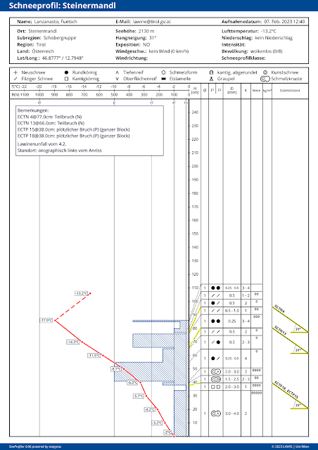
Das Profil wurde im Nahbereich des Lawinenanrisses aufgenommen. Die Störanfälligkeit variierte in Abhängigkeit der Schneemächtigkeit. An schneereichen Stellen war die Schneedecke in der Regel weniger störanfällig als an schneearmen Stellen. (Profil vom 07.02.2023)
This profile was taken near the avalanche fracture. The proneness to triggering varied, depending on snow depth. Where the snow was deep, the snowpack was ordinarily less prone to triggering than where it was shallow. (profile from 07.02.2023)


Avalanche accident Eisenkar (Geigenkamm) on 05.02.2023

Brief description

3 backcountry tourers were heading towards Eisenkar on the Geigenkamm ridge. During the ascent they met two descending groups of skiers, with whom they exchanged tense words about the avalanche dangers. The group was ascending up a steep slope when they heard settling noises and wanted to turn back. Thereupon a second slab avalanche triggered which swept all three persons with it. Two persons had airbags, were only partially buried. One person with an LVS beamer was completely buried. His companions succeeded in digging out this person in about 20 minutes, initiated reanimation efforts, but could not save him.


Magenta: Unfalllawine mit Verschüttungsstelle. Die Lawine war ca. 80m breit und 400m lang und löste sich auf ca. 2400m in einem extrem steilen SO-Hang. Violett: Kürzlich abgegangene spontane Lawinen (Foto: 05.02.2023)
Magenta: avalanche accident with point of burial. The avalanche was about 80 wide and 400m long, triggered naturally at 2400m altitude on an extremely steep SE-facing slope. Violet: previous naturally triggered avalanches. (photo: 05.02.2023) 


Notarzthubschrauber im Einsatz. Ellipse: Verschüttungsstelle (Foto: 05.02.2023)
Medical helicopter emergency operation. Ellipse: spot of burial. (photo: 05.02.2023)


Das Profil wurde etwas südlich versetzt an einem kleinen Hang aufgenommen. Es zeigt die bedeutsame Schwachschicht, die am Unfallhang wohl noch etwas ausgeprägter vorhanden gewesen sein dürfte. (Profil vom 05.02.2023)
This profile was taken a bit south of the small slope. It shows a clear weak layer which was probably more pronounced on the accident slope. (profile from 05.02.2023)


Accident accident Wannenkar (Kühtai - Geigenkamm) on 06.02.2023

Brief description

A ski tourer went alone from Niederthai towards Hohe Wasserfalle, preferring for his destination an ascent in the Wannenkar as far as the northern end of the huge bowl, where at about noon he made ready to descend. At nearly 4:00 pm his family reported him missing. During the evening with the assistance of drones, an avalanche zone was pinpointed. The following morning this area was searched by the Alpine Police and Mountain Rescue Squad with an LVS beamer. The buried signal was swiftly located, but the rescue operation was too late.


Lawine Wannenkar mit Einfahrtsspur und Verschüttungsstelle (verdeckt hinter der Geländekuppe). Die Lawine löste sich in einer Höhe von etwa 2600m in einem extrem steilen SO-Hang. Die Lawine war ca. 200m lang und 350m breit. (Foto: 07.02.2023)
Avalanche Wannenkar with entry track and point of burial (concealed behind the knoll). The avalanche triggered naturally at about 2600m on an extremely steep SE-facing slopes, was about 200m long and 350m wide. (photo: 07.02.2023)


Einfahrtsspur Wannenkar. (Foto: 08.02.2023)
Entry track Wannenkar. (photo: 08.02.2023)


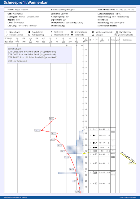
Schneeprofil mit einer Schwachschicht aus kantigen Kristallen und Schwimmschnee unterhalb einer dünnen Schmelzkruste (Profil vom 07.02.2023)
This snow profile shows a weak layer of faceted crystals and depth hoar beneath a thin melt-freeze crust. (profile from 07.02.2023)


Impressions from last week


Der Sturm auf den Bergen war am 04.02. außergewöhnlich. Durch die großräumigen Verfrachtungen und die dadurch bedingte Zusatzbelastung lösten sich einige Lawinen spontan. Bergerkogel im Villgratental (Foto: 04.02.2023)
The storm winds in the mountains on 4 February were unusual. Due to massive snow transport and the additional weight on the snowpack, several large - in isolated cases, very large - slab avalanches triggered naturally. Bergerkogel in Villgratental (photo: 04.02.2023)


Der Wind griff auch in den Waldbereich über. Frade (Foto: 04.02.2023)
Winds extended down into forested regions. Frade (photo: 04.02.2023)


Sehr gute Sprengerfolge in weiten Teilen Tirols, wie hier in der Schlick (Foto: 05.02.2023)
Very successful artificial triggerings throughout Tirol, e.g. in the Schlick above (photo: 05.02.2023)


Schneebrettlawine im Waldgrenzbereich. Außerfern (Foto: Adolf Kerber)
Slab avalanche near the timberline. Ausserfern (photo: Adolf Kerber)


Auf steilen Wiesenhängen: Potential von kleinen und mittelgroßen Gleitschneelawinen. Kelmen (Foto: Elisabeth Zangerl, am 07.02.2023)
On steep grass-covered slopes: potential small-to-medium sized glide-snow avalanches. Kelmen (photo: Elisabeth Zangerl, on 07.02.2023)


Outlook

Following days of extremely high avalanche activity, the number of avalanche prone locations decreases day by day, thereby reducing avalanche danger levels. Nevertheless, the situation remains treacherous, since danger zones are hard to recognize and occur in all aspects, increasingly frequently above 1800m. In Ausserfern there are reports of heightened proneness to triggering of the snowpack near the treeline and even below it. Currently, we advise against skiing into large, untracked, very steep slopes. Avalanches are most triggerable in transitions from shallow to deep snow. Although remote triggerings were also a current cause in several recent avalanches (e.g. avalanche accident Hohe Warte on 5 February), there were no further reports of remote triggerings. For that reason, we no longer find remote triggerings to be a current threat.

Conditions are more favorable at low and intermediate altitudes in the regions where snowfall has been heaviest and there, where the terrain has been tracked throughout the winter.