Wednesday, 13 February 2019

Caution: fresh snowdrifts in very steep, shady ridgeline terrain. Beware loose + glide-snow avalanches!

A new round of fresh snow was unloaded on Tirol, most in the northern, eastern and furthermost western regions, as well as in the eastern Zillertal Alps. Frequently between 30 and 50 cm of fresh snow was registered, the prize was won by the Seegrube measurement station above Innsbruck (once again): just under 100 cm.


Fresh snow started Sunday evening, 10.02, amid strong winds which have now tapered off. “Am Adamsberg” weather station in Paznauntal

Accompanied by low temperatures and strong winds, wide-ranging snowdrifts accumulated, some of them trigger-sensitive.

Snowfall in the Lienz Dolomites  (photo: 12.02.2019)

Unpleasant: strong winds transporting the snow, en route in the northern Stubai Alps.  (photo: 12.02.2019)

The fresh snowdrift accumulations are easiest to trigger in very steep, untracked, shady terrain and in general in very steep terrain adjacent to ridgelines. Weak layers for slab avalanches are the surface hoar on shady slopes below the timberline and, more frequently, the older powder snow (“burled powder”). In addition, the cold powder covered by the drifts could also serve as a weak layer, particularly in sunny terrain where before 10.02 a melt-freeze crust often formed. Caution is urged towards the upper-level faceted weak layers at 2300-2600 m referred to in the last blog. In the central and southern parts of East Tirol, a latent old-snow problem still threatens in ground-level layers, increasingly so on north-facing slopes.

Particularly on shady slopes at low and intermediate altitudes, surface hoar was observed last week. Obernbergtal  (photo: 05.02.2019)

“Burled powder” as potential (but not highly delicate) weak layer.  Kitzbühel Alps  (photo: 07.02.2019)
On sunny slopes, the snowpack became moist last week. Kitzbühel Alps  (photo: 07.02.2019)

Starting today, 13.02, a long period of fine weather and brilliant sunshine is in the offing, with continually rising temperatures. Impulses supplied by warmth and solar radiation will unleash numerous loose-snow avalanches in extremely steep, sunny terrain today, 13.02. In addition, isolated naturally triggered releases of the fresh snowdrifts cannot be ruled out in sunny ridgeline terrain. On steep slopes where the ground is smooth, heed the risks of gliding snow masses; and glide-snow avalanches on steep, grass-covered slopes. Also rooftop snowslides have been increasingly observed during the last few days.

Loose-snow avalanches in rocky terrain. Photo of Mieming range on 04.02.2019, a similar syndrome expected today, 13.02.

Ridgeline slab in foreground, gliding snow masses in background. In the interim, deep snowdrifts have accumulated near ridgelines. Kitzbühel Alps  (photo: 07.02.2019)

Slab in Villgratental, fractured from a deep layer.  (photo: 07.02.2019)

Slab in Defereggental. A deep weak layer was the primary cause.  (photo: 12.02.2019)

We recommend a high degree of restraint today. Freshly generated drifts in very steep terrain should be circumvented wherever possible.

The positive side: we expect the snowpack to stabilize rapidly wherever there is not a latent old-snow problem. In addition, springtime conditions will soon make their entrance.

A powder dream come true in many parts of Tirol. Defereggental  (photo: 12.02.2019)

Saturday, 9 February 2019

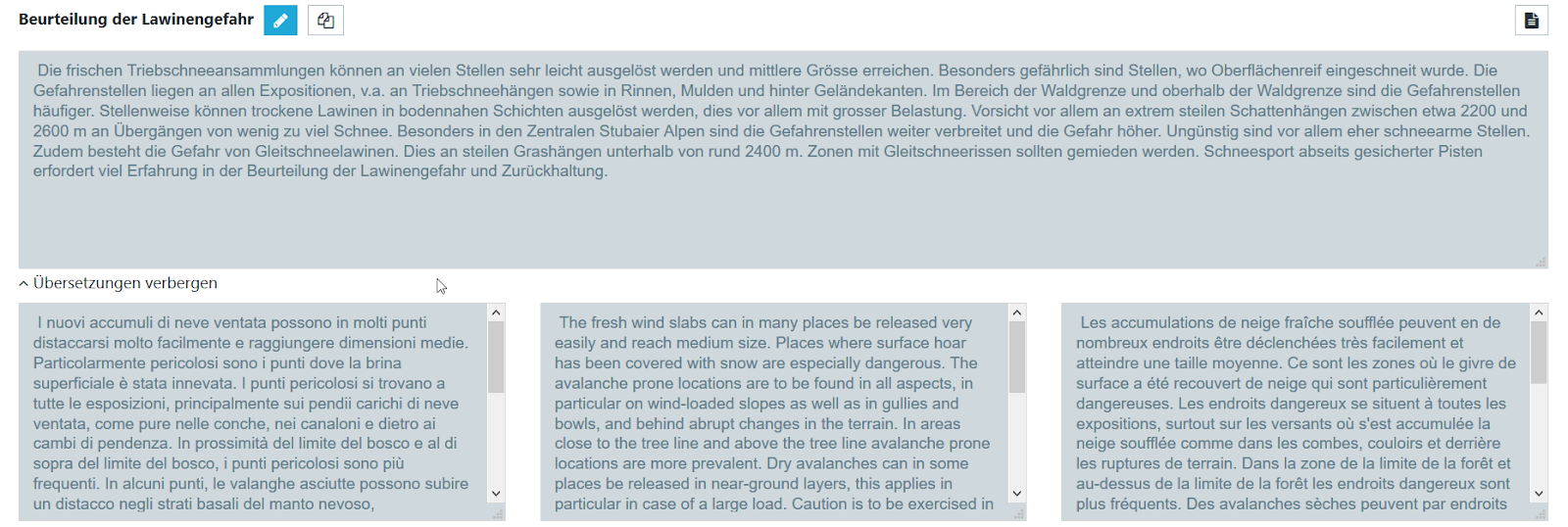
Avalanche forecast in 3 languages: the phrase catalog

Avalanche warnings in the Alps


The Alps are an extraordinarily complex mountain range, unique on earth. In no other mountain range of the world do so many countries and cultures meet in such a compressed area. Eight nations with five highly contrasting languages share a space which is only one third the area of Italy (surface area of the Alps: 200,000 km2). And the various avalanche warning services in this area are just as multifarious as the Alps themselves.

Depiction of warning zones of the various avalanche warning services in the European Alps on European Avalanche Warning Services website  (www.avalanches.org).


Throughout the wide-spanning arc of the Alps, more than 30 different avalanche warning services prepare and publish a regional avalanche forecast for the public. The differences are startling: some of the warning services publish descriptions of the current situation (bulletin); others prognosticate avalanche danger for the near future (forecast); some warning services publish their reports and warnings every day, others at longer intervals. The time of publication of avalanche bulletins and forecasts varies from country to country. The largest disparities, or those causing the greatest concern, are those which appear on the websites of the respective warning services: the products look completely different, present their data in different ways with different formats and depictions and frequently are available only in the language of that given country.


The products of the various avalanche warning services often have widely disparate appearances and are usually only in the language of that one country. Above left, Veneto (Italy), above right Vanoise (France)


The Euregio Avalanche Report


The intensive collaboration of the avalanche warning services of the European region Tirol-South Tirol-Trentino and the compilation and publication of a joint avalanche forecast is something brand new, never before seen in the world. The Avalanche Report spans a bridge over national borders, over different languages, presents a unified look in several languages. Both a Trentino backcountry skier in Tirol and a Tirolean snowshoe hiker in Trentino will find a familiar report whenever they consult it. All the relevant current information on avalanche dangers can be gleaned at a regular time of day in his/her own language. And so that even the British and Slovenes in South Tirol can be given assistance, the report is also presented in English.


The new Avalanche Report in Euregio South Tirol-Tirol-Trentino: in several languages and cross-border coverage.


For static websites whose contents do not change (or change only seldom), a three-language depiction can be brought about with relatively little effort. Texts are translated once and remain the same for an indeterminate period of time.

It gets complicated, however, when it is a matter of the avalanche forecast, which is our main product. This is published each and every day at 5:00 pm in all three languages simultaneously. When the situation changes, an update subsequently follows at 8:00 in the morning. In case of extraordinary situations, an update is possible at any time of day. The texts of danger description and snowpack analysis change daily. In addition, the number of avalanche-endangered regions and thus, the texts which need to be translated, vary greatly (see Blog).

Eine professionelle Übersetzung der Lawinenvorhersage in zwei weitere Sprachen wäre somit mit enormem Aufwand und nicht zuletzt finanziellen Kosten verbunden - wäre da nicht der Satzkatalog!


The phrase catalog

The phrase catalog is a fully automated translation system developed specially for avalanche forecasts by the WSL Institute for Snow and Avalanche Research SLF in Davos.

It is based on a complex catalog of pre-defined sets of words which together build a vast variety of sentences and then are translated into all required languages. When an avalanche forecast is generated, the descriptions of avalanche danger and snowpack analysis are not written freely, but combined like a linguistic puzzle consisting of pre-defined pieces, so that it is immediately available in all three languages. The point of departure, i.e. original language, can be German, as is the case in Tirol and South Tirol, or also Italian, as is the case in South Tirol and Trentino.


Through the permutations of linguistic building blocks, vast contents stand at the ready and can be combined to describe each and every situation precisely.


The phrase catalog enables warning services to generate a translation of avalanche danger assessment and snowpack analysis into German, Italian, English and French automatically.


Since Germanic and Romance languages have quite different grammar, there are built-in limitations to automated translations. The result is generally shorter and simpler sentences which might in some cases sound unusual or repetitive. What is more important, however, is that the information is presented clearly and understandably in all the required languages.


With the help of the phrase catalog and the automated translations connected to it, the avalanche forecaster is directly and immediately present for all readers in all requisite languages in the published report.


Conclusion


The new Avalanche Report in Euregio South Tirol-Tirol-Trentino is no longer written freely by a translator, but rather, assembled automatically by a complex catalog of highly varied sentences which produce countless combinations and which at the push of a button can then appear in German, Italian and English.


Using the phrase catalog demands a big transformation of the avalanche forecasters who stand on the front line. Yet the advantage of the Avalanche Report - that up-do-date versions are always available in three languages - have higher priority.
  

This new system was made possible by the successful collaboration with our colleagues at the avalanche warning service at the WSL Institute for Snow and Avalanche Research SLF in Davos. We extend a deep vote of thanks for their cooperative assistance.