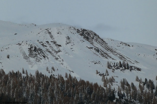
After a “golden autumn” comes the launch of winter
Meteorologists are of one opinion: the weather is changing over the long term. Right on time for winter’s meteorological start, wintery temperatures are expected throughout Tirol. To begin with, more snowfall is anticipated in the southern and southeastern regions of the land, then the precipitation will move north and northwest.
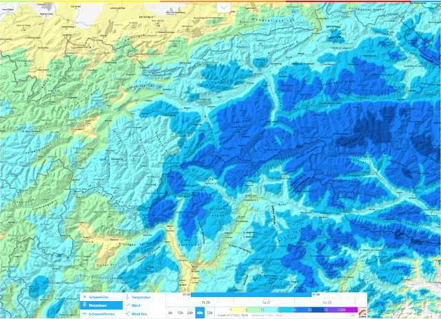 |
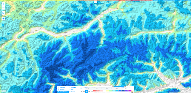
| 48-hr fresh snow forecast on 26.11.2021. Most snow expected in southern Stubai Alps, towards southwest. |
As a result of fresh snow, regional increase in avalanche danger. Caution on shady slopes!
In the regions of Tirol where precipitation is heaviest, a significant increase in avalanche danger levels has to be expected by winter sports enthusiasts. This applies most of all to zones where there is already a cohesive, area-wide snowpack. Let’s have a look at the weather developments during November, including the closely linked processes that went on inside the snowpack. That’s how we can filter out the potential problem zones.
November 2021: three major bouts of precipitation – otherwise sunny and dry
There were three rounds of intensive snowfall in November 2021 (cutoff date: 26.11): on 1-2 November; on the 4th; and 13-14 November; in the interim there was tranquil, lovely autumnal weather.
 |
Weather in November from the weather stations on Pitztal Glacier: beautiful weather predominated.
Three significant bouts of precipitation. |
Focus of the last intense round of precipitation (13.11-14.11) was in the Ötztal-Stubai-Tux-Zillertal Alps.
 |
| Distribution of precipitation 13 - 14 November. Hotspot (40 cm of fresh snow) was in the Axamer Lizum, Stubai Alps. |
Beautiful weather reinforced generation of weak layers
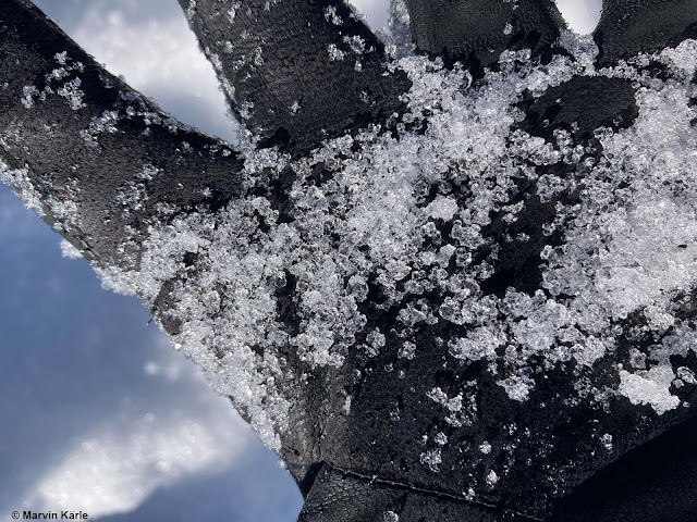
As pleasant as the period in November was when there was no precipitation, avalanche forecasters fasten on the effects of this weather development. For, during this extended period of fine weather with star-studded nocturnal skies, the snowpack radiated outgoingly and cooled significantly. Due to immense temperature disparities and the relatively shallow snowpack, snow crystals become large and loose (expansively metamorphosing). Currently we find large amounts of loosely-packed, faceted crystals in the uppermost layers of the snowpack, also some surface hoar. Both constitute potential weak layers for the coming snowfall. The entire process needs to be viewed from afar, however: what seems most important at the launch of the season is the overview of snow distribution, since there is not snow on the ground in all regions. Or else, it has already melted.
Snow distribution throughout the land
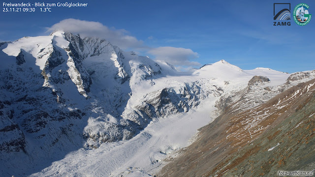
Webcam-photos make our work much easier. That way we gain a wide-ranging picture of snow distribution throughout the land.
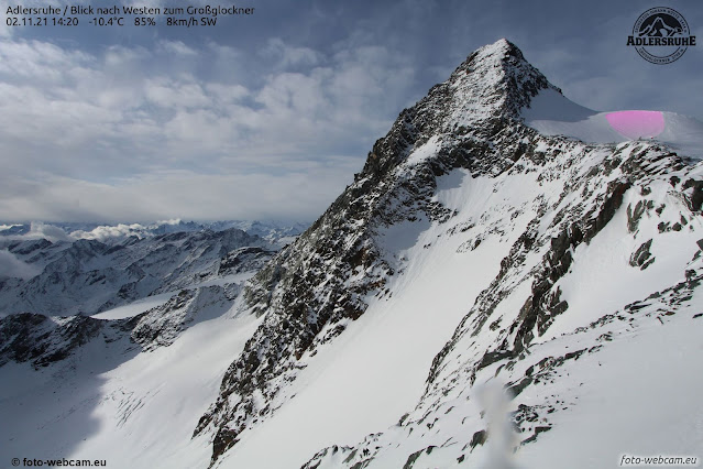
View towards Grossglockner: very steep sunny slopes are bare of snow up to high altitudes.
 |
| The Kitzbühel Alps got the least amount of precipitation in summertime. Hardly any cohesive, area-wide snowpack is evident. |
![Sehr gut zu erkennen: Schneeverteilung um diese Jahreszeit ist stark expositions- und höhenabhängig. [Ausnahme Kunstschnee :-)] Sehr gut zu erkennen: Schneeverteilung um diese Jahreszeit ist stark expositions- und höhenabhängig. [Ausnahme Kunstschnee :-)]](https://blogger.googleusercontent.com/img/a/AVvXsEgb6C3YtUWeYX_Pdalbf5zarF2FeUIK0bc6ua1Ax0GSbcjGS2RJhKk_Ok9MEXnmooSKGNpBij3gJlsc7kMxvqoysMoHijFrkZQ_UleBJoJrXy7irK7Pi30_DloKGTnO_uc4afWDvCc-zVySgVgFG9wsBve4ld96rEB-T5vKB3GPfvEiEPDCelDRgJvhhw=w640-h360) |
| Arlberg region. Easily recognized: snow distribution at this juncture of the season is heavily weighted to aspect and altitude (with the exception of artificial snow). |
 |
| Striking: shady slopes are wintery with lots of snow to ski on; the sunny side is pretty much bare of snow. Kalkkögel Massif (photo: 24.11.2021) |
Intensive snowpack analyses
In early winter it is essential to analyze the development of the snowpack. We were often in outlying terrain with our observers and with the help of the state helicopter had the opportunity to carry out targeted snowpack analysis.
 |
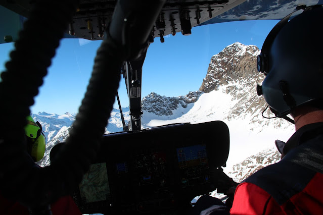
En route in the state helicopter to our systematic snowpack analyses at neuralgic points
(photo: 23.11.2021) |
Our analyses produced a multi-faceted picture of the current situation:
Scenario 1: On shady slopes with a cohesive, area-wide snowpack
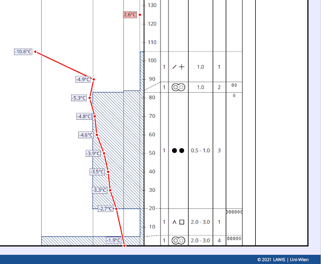
The snowpack is expansively metamorphosed (faceted) on the surface, thus, loosely-packed and a very weak layer for the bonded snow which gets deposited on top of it. Inside the snowpack there are frequent thin crusts embedded up to at least 2700 m. In the regions where there has been fresh snow, particularly with wind impact, trigger-sensitive snowdrift masses can swiftly be generated. In steep terrain, even the additional loading of one single skier is sufficient to trigger ta release. Behind wind-impacted, steep terrain edges, in addition, small-to-medium naturally triggered slab avalanches can be expected.
 |
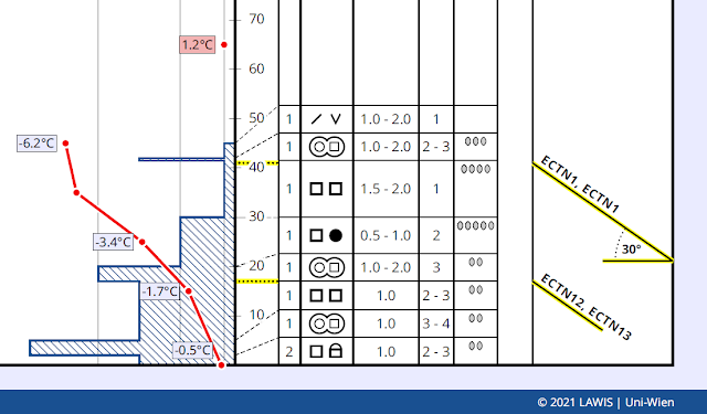
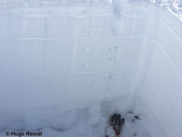
| Snow profile in Axamer Lizum, Stubai Alps, from 25.11.2021. North, 1980m, 30°: problematic for the coming snowfall are the loosely-packed layers near the surface. |
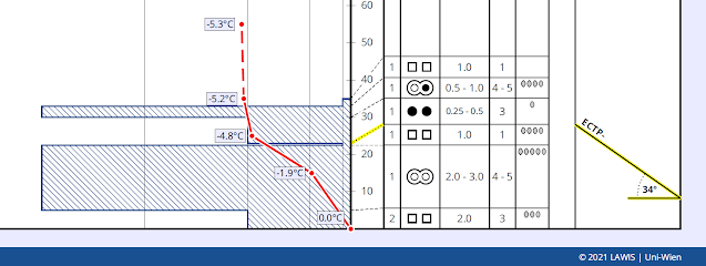
Scenario 2: Sunny slopes with a cohesive, area-wide snowpackIn this case, altitude and steepness gradients play a major role. Wherever it is very steep you often find a very hard, sometimes thick melt-freeze crust near the surface. Although frequently there are potential weak layers embedded beneath it in places, a disturbance of the old snowpack is unlikely. On the other hand, at higher altitudes and in sectors where little snow has remained, you find much thinner melt-freeze crusts and, beneath them, loosely-packed and faceted crystals in many cases, a very unfavourable situation for the coming snowfall.
 |
| Snow profile near Steinernes Lamm in northern Zillertal Alps on 23.11.2021. South, 2675m, 34°. Faceted weak layer due to Danger Pattern 4 (dp.4: cold on warm), above that a massive melt-freeze layer. In addition, hardly a cohesive area-wide snowpack. Low potential danger for coming snowfall. |
 |
| Snow profile in Axamer Lizum, Stubai Alps, on 25.11.2021. Southeast, 2090m, 36°. Marked weak layer beneath a thin melt-freeze crust. Also here the snowpack at this altitude is minor, however. |
 |
| Here a picture which fits with the snow profile above. A thin melt-freeze crust is seen on the surface at about 2300m in ESE to E aspects; beneath that, faceted crystals. |
Scenario 3: In high alpine regions, weak layer at ground level
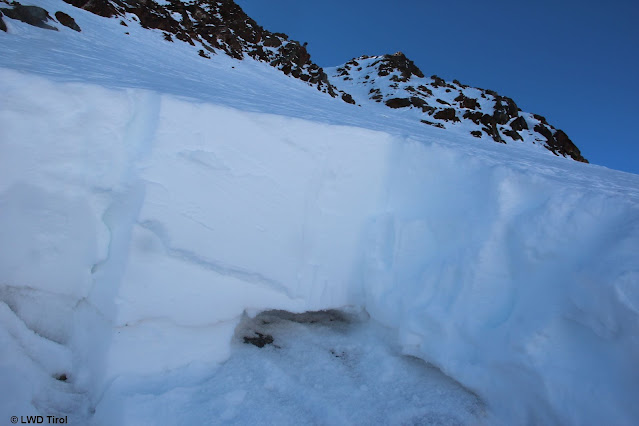
Following the snowfall at the beginning of November, the old-snow problem indicated above revealed itself through a ground-level weak layer in the form of wide-ranging slab avalanches in high alpine terrain, exclusively on glaciers.
 |
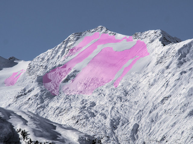
| Wide-ranging slab avalanches on the Schalfkogel, Ötztal Alps (photo: 06.11.2021) |
 |
| Three naturally triggered slab avalanches and one remotely-triggered release on Linker Fernerkogel (photo: 09.11.2021) |
 |
Ground-level weak layer from early winter. Glacier ice at base. Daunferner, Stubai Alps.
Northeast, 3060m, 40°. |
In the interim we assume that these weak layers can only be triggered by large additional loading, particularly in transition zones from shallow to deep snow in very steep terrain. The forecasted fresh snow will probably not be enough for naturally triggered avalanches to trigger in the ground level weak layers.
 |
Above, a picture of a ground-level weak layer in the Tiefenbachferner glacier, Ötztal Alps
(photo: 09.11.2021) |
Scenario 4: Snow-bare zones – frequent gliding snow on steep grass-covered slopes
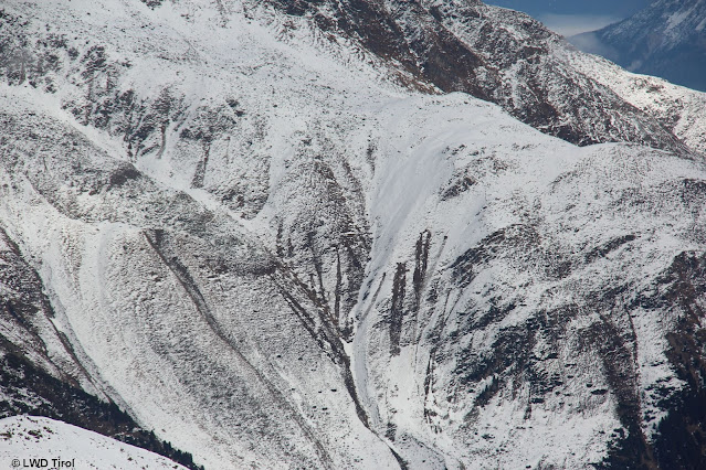
Wherever it is currently bare of snow, snow can glide away over smooth, grass-covered slopes or rock slabs. This will be the case even more where intensive snowfall follows. But even if the snowfall is minor, slides can occur frequently.
 |
| A picture from Stubai Valley on 17.11.2021. The just-fallen snow slides over very steep grassy slopes. In some spots, also small moist loose-snow avalanches trigger, something which can be frequently expected after the coming snowfall. |
CONCLUSION
In the immediate future, danger zones for avalanche releases will swiftly increase. Those who are in outlying terrain need to have experience in assessing avalanche dangers on-site, but they also need to exercise great restraint. Caution is urged due to protruding stones and the hazards of injury from them.
 |
| In areas where precipitation is heavy and wind impact great, even zones on public ski slopes have a certain hazard of avalanches. Above, a picture of an avalanche on the Stubai Glacier on 15.11 due to a fresh snowdrift problem. (photo: 17.11.2021) |
 |
| Stones and rocks: a not-to-be-underestimated danger in early winter. Injury calls. (photo: 17.11.2021) |
START OF DAILY EUREGIO-AVALANCHE BULLETINS on 01.12.2021
Here, once again, the notice: we are launching the daily publication of our EUREGIO Avalanche Bulletins on 30.11.2021 together with our South Tirolean and Trentino colleagues. At 5:00 PM the first report will appear for 1 December 2021. We are looking forward to the coming winter.



![Sehr gut zu erkennen: Schneeverteilung um diese Jahreszeit ist stark expositions- und höhenabhängig. [Ausnahme Kunstschnee :-)] Sehr gut zu erkennen: Schneeverteilung um diese Jahreszeit ist stark expositions- und höhenabhängig. [Ausnahme Kunstschnee :-)]](https://blogger.googleusercontent.com/img/a/AVvXsEgb6C3YtUWeYX_Pdalbf5zarF2FeUIK0bc6ua1Ax0GSbcjGS2RJhKk_Ok9MEXnmooSKGNpBij3gJlsc7kMxvqoysMoHijFrkZQ_UleBJoJrXy7irK7Pi30_DloKGTnO_uc4afWDvCc-zVySgVgFG9wsBve4ld96rEB-T5vKB3GPfvEiEPDCelDRgJvhhw=w640-h360)
