Thursday, 28 February 2019

Some fresh snow, wind, temporarily receding temperatures. Caution: gliding snow!

Outlook

On Thursday night a cold front will reach us, bringing strong NW winds to the northern flank of the Alps and temporarily terminating the springlike conditions. Already on Thursday, 28.02, the cold front has announced its approach with intensifying NW winds and slightly decreasing temperatures at intermediate and high altitudes.

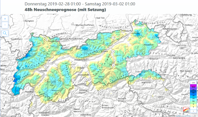
About 20-30 cm of fresh snow is anticipated by Saturday, 2 March, particularly in the northwestern barrier-cloud regions along the Vorarlberg border and in the Karwendel. The snowfall level will initially lie at approximately 1700 m, then descend to nearly 1000 m, according to the ZAMG Weather Service. The cold front will be accompanied by moderate-to-strong velocity northwesterly winds.


The precipitation will initially fall as rain up to intermediate altitudes. On Friday, 1 March, it will create heightened danger of glide-snow avalanches below about 2000 m. In the western parts of North Tirol, avalanche danger level 3 (“considerable”) will be reached. In those regions the first cloudbanks will move in during late evening on 28.02 and impair outgoing radiation of the snowpack, particularly on south-facing slopes which are thoroughly wet. The rain impact will then increase the moisture content of the snowpack and enhance gliding over steep, grass-covered slopes.

Further to the east in North Tirol, the snowpack will generate sufficient outgoing (longwave) radiation until nearly midnight. In addition, there will be less rainfall there. Thus, compared to the western regions, the likelihood of glide-snow avalanches will be less there.

Open glide cracks and a recently released glide-snow avalanche bear witness to intensive snowpack gliding over steep grass-covered slopes, Northern Massif.  (photo: 26.02.2019).

At high altitudes and in high alpine regions, fresh snow and winds will generate the accumulation of fresh snowdrifts, which will then be deposited adjacent to ridgeline slopes and in gullies and bowls. In this connection, the structure of the snowpack is the most important aspect: it is currently quite irregular. This can be evaluated as positive (see Review). The freshly generated snowdrift accumulations are triggerable only in isolated cases, rarely released as avalanches, most likely on very steep, shady, until now wind-protected slopes. There, the old snowpack surface consists of loosely-bonded, faceted, expansively metamorphosed snow crystals in some places.

In East Tirol, the avalanche situation remains predominantly favourable apart from the Main Alpine Ridge. In those regions, the snowpack surface consolidates quite well in the course of nocturnal outgoing radiation. Precipitation hardly exists. Deeply embedded inside the snowpack are isolated trigger-sensitive weak layers which can be triggered by large additional loading on very steep shady slopes at 2000-2600 m. The danger zones occur quite seldom but are very difficult to recognize, unfortunately. Areas where the snow is shallow in extremely steep terrain are the most threatening.

Apart from possible (generally minor) avalanche danger, one needs to give due consideration to the other alpine dangers. Wherever the snowpack was able to freeze during the night, there is acute danger of being forced to take a fall on the hardened snowpack surface on very steep sunny slopes during the early morning hours. This proved fateful for a backcountry tourer on the Reichenspitze on the border of Tirol and Salzburg yesterday, 27.02. On the way from the summit to the ski deposit spot, he took a fall for several hundred meters and lost his life. Caution is also urged towards the cornices which are often vastly overbearing (similar to glide-snow avalanches) in the unpredictability of their threat.

Areas below large cornices need to be critically assessed. Totenfeldscharte, Silvretta.  (photo: 27.02.2019).

As the weekend approaches, weather conditions are improving, according to ZAMG Weather Service forecasts. Winds are shifting to southwesterly, it is turning milder, with foehn influence. Avalanche danger is not expected to change significantly. The snowdrift accumulations at high altitudes will no longer be likely to trigger. The glide-snow activity will recede after the period of precipitation. As a result of higher daytime temperatures and solar radiation, avalanche danger will increase again over the course of the day. In the regions where recent snowfall has been heaviest, numerous relatively small-sized loose-snow avalanches can be expected on extremely steep sunny slopes.

At the beginning of next week variable and instable weather conditions are anticipated. Temperatures will drop once again and a small amount of fresh snow is expected.
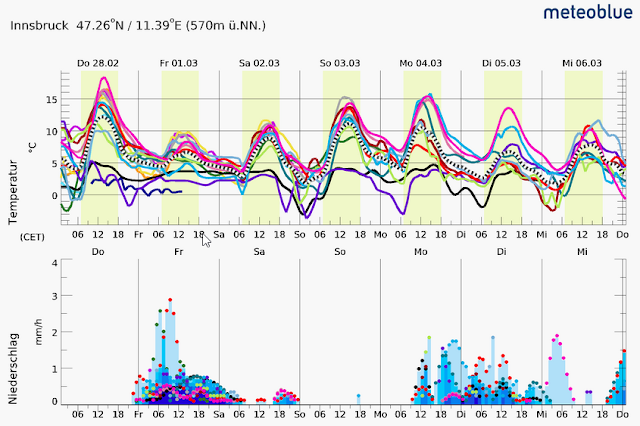
Starting at the beginning of next week, skies will be variably cloudy. Temperatures will drop.  (©meteoblue).

Review 

Following the precipitationof last Friday, 22.02, conditions have turned springlike again, with mild temperatures and lots of sunshine. the zero-degree level rose to about 3000 m. The avalanche situation was favourable over widespread areas and was subject to the fluctuations of a daytime danger cycle.

Favourable backcountry conditions in recent days were an inspiration for many to leave the office and head into outlying terrain. Sonnblick, Hohe Tauern  (photo: 27.02.2019).

The snow and avalanche situation also permitted steep descents. Haagspitze, Silvretta.  (photo: 27.02.2019).

First butterflies have already awakened from their hibernation, are carried to the heights by the winds. This beautiful specimen was spotted at about 2900 m on the Schnapfenspitze in the Silvretta.  (photo: 26.02.2019).

Due to heavy solar radiation, the snowpack on very steep south-facing slopes is thoroughly wet up to about 3000 m. On north-facing slopes, on the other hand, the snowpack has for the most part remained dry up to 2000 m.

On sunny, very steep slopes the snowpack is nearly isotherm up to 3000 m. In zones where the snowpack is shallow, the wetness extends all the way down to the ground. S; 2980 m; 37 degrees  (©LWD Tirol).

Stability tests have generated only partial fractures at most. The snowpack is well consolidated over widespread areas and quite stable.  (photo: 26.02.2019).

Due to the very dry and clear atmosphere, the snowpack generated adequate outgoing radiation during the nocturnal hours. The wet snowpack surface froze during the night, forming a crust capable of bearing loads. Good quality corn snow was the result in many places. Only in late afternoon did the uppermost layers become thoroughly wet. The wetness of the snowpack occurred relatively slowly, due to the very dry, relatively warm air masses which drew much of the moisture from the snowpack. Thereby, the snowpack also forfeited some of its mass, since the water bonded as condensed water inside the snow crystals was “sucked up” by the air, in effect.

Corn snow in far-reaching parts of Tirol, such as here on the Freihut in the northern Stubai Alps.  (photo: 26.02.2019).

Gliding-snow activity is generally subject to daytime fluctuations. Glide-snow avalanches have been observed in late afternoon as well as during the evening and in nocturnal hours. This in all probability has to do with the delayed penetration of water into the snowpack down to the lowermost ground-level layers.

Glide cracks and a convex snowpack surface are indicators of snow-gliding. Grieskopf, western Verwall Massif  (photo: 27.02.2019).

Fracture areas of a glide-snow avalanche on Malgrübler, western Tux Alps  (photo: 24.02.2019).

Deposit of a glide-snow avalanche in the Silvretta (photo: 27.02.2019).

Solar radiation, wind influence, wet loose-snow avalanches from steep, rocky terrain as well as people-and-animals have all had enormous impact in the current snowpack surface. From place to place, the impact is irregular to inhomogenous. This places the snowpack surface in a very good position for coming snowfall: fresh snowdrifts triggerable only over very limited spaces, if at all.

Heavily wind-impacted snowpack surface on the Grossen Wilden in the Allgäu Alps.  (photo: 24.02.2019).

Ski tracks ‘worked on’ by the wind in Kühtai.  (photo: 24.02.2019).

A corn-snow mirror was observed in many places over recent days. Jamtal, Silvretta.  (photo: 26.02.2019).

Sunday, 24 February 2019

The Zwölferkogel and Ammerwald Avalanches

The Zwölferkogel Avalanche

Overview of Zwölferkogel avalanche on 23.02.2019. The avalanche extended to the Finstertal reservoir (2300 m). photo: 24.02.2019)

Yesterday, on 24.02, we examined the site of the accident below the Zwölferkogel in the Kühtai where a person died. As described in the previous blog, it was a small slab avalanche. The cause was a recent snowdrift problem. Due to very strong, in some cases storm-strength winds, a hardened wind crust formed on the snowpack surface on top of softened layers. The avalanche triggered when a mountaineer traversed the 35° gradient NE slope. The avalanche was about 15 m wide and 70 m long. The depth of the fracture is estimated to have been 20-30 cm. The person was buried 1 meter deep, and was found by an avalanche search dog.

Close-up of the avalanche. Parts of the avalanche flow were drifted closed by winds. The patches visible in photo are mostly ice patches, marking various levels of the reservoir.  (photo: 24.02.2019)

The stability tests which we conducted in the vicinity of the accident were able to locate a fracture below the wind crust, but fracture propagation was not (no longer) possible. This observation fits with the reports arriving today that freshly generated snowdrift accumulations were no longer triggerable. In isolated cases, triggering might still be possible at high altitudes on very steep, shady slopes.

Location of snow profile slightly north of the accident site at 2370 m, north, 26°. The uppermost hardened wind crust together with the lower-down softer, faceted layer created the prerequisites for the slab avalanche triggering. Our stability tests demonstrated only partial fractures. (profile from 24.02.2019)
The Ammerwald Avalanche

As was seen yesterday, this avalanche occurred in Bavaria and will be investigated by our German colleagues. It is already clear that it was a glide-snow avalanche which triggered naturally in a forest clearance and then divided into three plummeting arms. The search for a still-missing person was continued today, but without results.

Glide-snow avalanche in Ammerwald.  (photo: 23.02.2019)

Saturday, 23 February 2019

Short update on avalanches in Tirol

Tirol headquarters was informed about three avalanches with persons involved today, 23.02.2019:

Ammerwald, vicinity of Plansee

Avalanche in Ammerwald

This was a glide-snow avalanche. According to currently available information, one person died, one person was injured, one is still missing. The search has been temporarily interrupted, will be continued tomorrow. Details will follow.

Zwölferkogel at Finstertaler Reservior in Kühtai

Avalanche Zwölferkogel. Precise location not yet known, but more-or-less inside the ellipse.
A small, fresh snowdrift accumulation triggered in extremely steep terrain. The avalanche extended all the way to the reservoir. One person was killed. Details to follow. 

Kleegrube, vicinity of  Hintertux Glacier

Avalanche Kleegrube

A small, freshly generated snowdrift accumulation triggered when one person was in the extremely steep terrain above the Spannagel House in the ascent to the Hoher Riffler. The person was not injured, but lost his skis and was subsequently transported to the valley in a helicopter.

All these avalanches fit into the current overall avalanche picture: the main danger stems from the threat of (unpredictable) glide-snow avalanches on steep, grass-covered slopes. Limited-spread and only relevant for a brief spell: the fresh snowdrift accumulations generated by strong winds particularly at high altitudes on north-facing slopes.

Northerly winds blowing at strong-to-storm strength since yesterday, 22.02.

Thursday, 21 February 2019

Fresh snow + strong winds spike avalanche danger

Outlook

Wedged between a high over southern Scandinavia and a low over Russia, Tirol will be pressed into a powerful northeasterly airstream tomorrow, Friday 22.02. Strong to storm-strength winds in the mountains will be the result, along with some precipitation, particularly in the eastern regions.


The fresh snow and, in some places, loosely-packed old snow will be transported by strong winds. New snowdrift accumulations will form, particularly in gullies, bowls and areas adjacent to ridgelines. The drifted masses will be deposited on top of a rather loosely-bonded old snowpack surface on shady slopes, consisting of decomposed and faceted snow crystals and, in some places near ridgelines, surface hoar (Nigg effect), thus will be triggerable even by minimum additional loading in places.

The snowpack surface on shady slopes often consists of settled, slightly metamorphosed (faceted) powder, so-called burled powder. This snow can briefly form a weak layer for the snowdrifts deposited on top of it. (photo: 21.02.2019)

In foreground, surface hoar is visible on shady slopes near ridgelines (Nigg effect). Strong northerly winds will presumably transport it, so that it will seldom persist as a weak layer. Gilfert in the Tux Alps  (photo: 21.02.2019)

In high alpine regions, particularly along the Main Alpine Ridge, avalanche prone locations occur more frequently, particularly in the eastern regions where recent snowfall has been heaviest. Freshly generated snowdrift accumulations in shady terrain and, increasingly, in very steep areas adjacent to ridgelines in all aspects can be triggered. Avalanche danger is increasing over widespread areas, it will reach danger level 3 (considerable) in the Zillertal Alps, Venediger Massif and Glockner Massif.

Fresh snow and strong winds will create heightened avalanche danger widespread.

Glide-snow avalanches remain an enduring threat this winter. They can grow to large size, in isolated cases even to very large size, particularly in the regions where snowfall has been heaviest. Thus, they need to be taken into consideration in all backcountry tour planning.

A popular ascent to the Kellerjoch in the Tux Alps. Many backcountry skiers seem to be unaware of the lurking dangers of glide-snow avalanches....  (photo: 21.02.2019)
Even taking a break at a high alpine pasture hut can have unpleasant consequences.  (photo: 21.02.2019)

In East Tirol, avalanches can be triggered in the weak old-snow fundament from place to place and grow to medium size. The most delicate spots are north-facing slopes at 2000-2600 m. Avalanche prone locations occur seldom and are ordinarily not recognizable by backcountry skiers. Areas where the snow is shallow, e.g. transitions from deep to shallow snow, are where avalanches love to trigger.

Over the weekend, weather conditions will improve. The high pressure system over Scandinavia will spread out in our direction. According to ZAMG weather forecasts, a tranquil and unseasonably mild weekend awaits us, with dry air and lots of sunshine.

Review

The inordinately warm temperatures which have reigned since the beginning of last week have had an enormous effect on the snowpack, especially on sunny slopes and at low altitudes in general.

The graph shows the maximum, minimum, average (gray line) and current snow depths (magenta) at our observation station in Obertilliach. We are now just below the average.

The chamoix are delighted when the snow recedes and temperatures rise. Nockspitze. Northern Stubai Alps  (19.02.2019).

Due to the snowpack becoming thoroughly wet to an increasing extent, together with the augmented penetration of water down to the ground, glide-snow avalanches continue to be observed. In isolated cases, they have also buried exposed roads. On the other hand, the frequency of wet loose-snow avalanches in extremely steep terrain has decreased.

An alm hut on the Rosskogel (Stubai Alps) pushes back against the gliding snow masses.  (photo: 19.02.2019).

In Seduk near Neustift in Stubaital, the deposits of a glide-snow avalanche press into the vicinity of houses.  (photo: 20.02.2019).
A glide-snow avalanche which released in the wee hours of Thursday (21.02) buried the Planseestrasse near Breitenwang (Reutte district) along a length of approximately 20 meters.  (photo: 21.02.2019).
A “glide-snow family” (l to r): a glide crack, next to it a fresh glide-snow avalanche (snow in the fracture area is still visible), next to that an older glide-snow avalanche, where the snow which came to rest has already melted, and next to that, yet another glide-snow avalanche which released before this one. (photo: 21.02.2019).

The plummet path of a glide-snow avalanche on the Bschlaber state road.  (photo: 18.02.2019).

Seen from the vantage point of a skier or freerider, the conditions over the last few days couldn’t have been better. The sunny, warm and windless days provided the best backcountry touring conditions imaginable. Avalanche danger in all of Tirol was low, apart from the risks of glide-snow avalanches.

In spite of above-average temperatures for this juncture of the season, shady slopes still had terrific powder to offer. The snowpack where it was not exposed to the sun enjoyed unimpaired outgoing radiation at night, so did not suffer in the slightest from the higher temperatures. The strong outgoing (longwave) radiation also brought about transformation of the fresh snow and drifts from Monday, 11.02, thereby making it unbonded. The essential “slab” for a slab avalanche, was thus no longer available. Seen from a skier’s point of view, the snow forfeited only very little of its quality.

Cloudless blue skies and the finest burled powder in Schmirntal  (photo: 21.02.2019).

Slopes exposed to sunshine, on the other hand, during the night were not able to relinquish the warmth which solar radiation poured into them during the daytime. The snowpack became increasingly moist. Following several cycles of re-freezing over the last few days, the first corn snow could be savored on steep, south-facing slopes. On east and west-facing slopes the sun was generally not strong enough to form a melt-freeze crust capable of bearing loads. The result: breakable crusts.

On steep south-facing slopes, corn snow was just waiting to be enjoyed. Nockspitze, Stubai Alps  (photo: 19.02.2019).

Sunday, 17 February 2019

Caution: glide-snow avalanches can grow to large size. Daytime avalanche danger cycle!

As expected, we are currently observing increasingly frequent glide-snow avalanches on steep, grass-covered slopes. This is the result of higher temperatures, more intensive solar radiation and the increasing wetness of the snowpack. The melt water penetrates to the base of the snowpack on grass-covered slopes and decreases its friction with the ground.

This applies increasingly often in sunny terrain up to about 2600 m. However, this type of avalanche is repeatedly observed in shady terrain up to intermediate altitudes as well.
Due to the extraordinary depths of the snowpack, glide-snow avalanches can take on great magnitude and have formidable runout zones. For example on 15 February a glide-snow avalanche swept over part of a parking lot at the Eisgratbahn in Stubaital, damaging a few cars. There were no injuries.

Glide-crack below avalanche protection barriers in Paznauntal  (photo: 16.02.2019)

Just a little later, a glide-snow avalanche triggered in that area. (photo: 16.02.2019)

Otherwise the avalanche release scene was quiet, with one exception. We were informed by the Alpine Police about an avalanche accident below the Tschadinhorn in the Schober Massif. Just after 11 o’clock a slab avalanche triggered when a group of backcountry ski tourers were on their ascent in the summit flank. The avalanche was approximately 70 m wide and 270 m long. The depth of the fracture was between 40 and 80 cm. The fracture occurred at 2965 m altitude. The terrain was between 30 and 43° steep and faced southwest. Two persons were swept along and injured. The weak layer consisted of faceted crystals above a melt-freeze crust. Above that was bonded snow. 

Avalanche accident Tschadinhorn in the Schober Massif  (photo: 16.02.2019)

Saturday, 16 February 2019

Possible weak layer at narrow altitudes on shady slopes

We are currently facing Danger Pattern 4 (cold on warm) from region to region in a very narrow altitude band.

Background: on Sunday 10.02 there was rainfall/wet snowfall in Tirol up to about 1600-2200 m. Subsequently, temperatures plummeted. The rain turned to snowfall. Thereafter it was persistently cold.Tthe weather is currently subject to great temperature fluctuations each day. During the clear nights, the upper layers of the snowpack cool off significantly. The measurable temperature disparities between the previously moist snowpack surface and the cold layers of snow deposited on top of it cause a melt-freeze crust to form, on top of which are faceted crystals in some places. Reports have come in from Ausserfern about a striking weak layer of faceted crystals on a north-facing slope at 2150 m (Fallesinspitze).

Notable: warm temperatures initially, precipitation starts, initially rain then snow. Significant drop in temperature - those are the prerequisites for Danger Pattern “cold on warm”  (dp.4)

We are currently of the opinion that these are isolated danger zones. Focal point: very steep, shady slopes in a narrowly defined altitude band (the altitudes are still difficult to pinpoint; we assume approximately 1800-2200 m). What is significant is that the weak layer occurs only where sufficient amounts of bonded snow lie deposited on top of it. That means the regions where recent snowfall has been heaviest – Arlberg, Ausserfern, Northern Alps and Kaiser Massif. Due to the persistently beautiful weather the snow deposited on top of the weak layer will gradually lose its inherent tensions (provided winds do not transport it).

Upshot: a presumably isolated and small-spread problem on very steep, shady slopes which needs to be observed for a brief spell. The problem might disappear before long.

Thursday, 14 February 2019

Current situation / More snow=more avalanches?

This blog is sub-divided into two parts:

  • Short and sweet: a description of the current situation.
  • A detour: "More snow = more avalanches?"

Current situation

In far-reaching parts of Tirol, quite favorable conditions currently reign. Avalanche danger generally depends on altitude during the morning hours: above about 2400 m danger is low, below that altitude danger is moderate due to the gliding snow problem. During the course of the day, avalanche danger increases to moderate for the most part, due to solar radiation and daytime warmth.

We currently are faced with two major threats: a gliding snow problem on steep, grass-covered slopes (also on rooftops of houses) and loose-snow avalanches on extremely steep, sunny slopes starting in the afternoon hours.


Typical picture of current situation: magenta arrows: loose-snow avalanches in extremely steep terrain; red ellipses: glide cracks on steep, grassy slopes. Northern Massif (photo: 13.02.2019)

 Clear-and-simple, the major peril stems from glide-snow avalanches which, due to the huge snow masses, can grow to dangerously large size. With conscientious tour planning, you ought to be able to assess avalanche starting zones (not always visible) as to whether glide-snow avalanches could release there, and thus, circumvent those areas. However, the risks of being forced to take a fall into open glide cracks also needs to be taken into consideration, particularly on freeriding tours in regions where snowfall has been heaviest.

Glide-snow avalanche in the Tux Alps on 06.02.2019. In background, loose-snow avalanches.

Today, 14.02.2019 at 15:55, headquarters in Tirol was informed about an avalanche accident at Bodenbachfall in Kaunertal. One person was severely injured, according to our information. We don’t yet have any details, but it is clear that even relatively small (loose-snow?) avalanches in a narrow stream bed can be very dangerous for ice climbers.

Avalanche accident at Bodenbachfall in Kaunertal. In depiction, right, slope gradient legend

Relegated to back-seat status recently: the snowdrift accumulations in high-alpine, shady, very steep terrain adjacent to ridgelines which can, in quite isolated cases, be triggered.

Current conditions remind one of springtime: star-studded nocturnal skies cool the snowpack down. On sunny slopes, a melt-freeze crust forms during the night. This is currently still breakable. In a few days, however, according to current weather forecasts of the ZAMG Weather Service, a melt-freeze crust capable of bearing loads will form, at very least at low and intermediate altitudes on very steep to extremely steep slopes. During the course of the day, this crust will soften and forfeit its firmness. Whoever ventures into outlying terrain early enough, will be rewarded by superb corn snow.

In the central and southern parts of East Tirol (the regions where we are still facing an old-snow problem) the situation has improved noticeably, compared to the beginning of February; nevertheless, the old-snow problem remains relevant. In those regions, one needs to ski defensively, particularly in shady terrain. In sunny terrain, caution is required towards the heightened proneness to triggering of the weak layers near ground level due to the increasing wetness of the snowpack.


More snow = more avalanches?

In far-reaching parts of Tirol there are currently massive amounts of snow down to low lying areas. What effect does all this snow have on the course of the winter with regard to snowpack stability and avalanche danger?

A little detour: types of avalanches

We distinguish three major types of avalanches, depending on their trigger mechanism:
  • Slab avalanches,
  • Loose-snow avalanches &
  • Glide-snow avalanches
Slab avalanches are the classic type of skier-caused avalanche. They are responsible for more than 90% of all accidents. For this type of avalanche, 4 ingredients are necessary: a slope of at least 30° steepness gradient; a bonded slab; a weak layer beneath it with suitable tendency towards fracture propagation; and a trigger mechanism.

Fracture of a slab avalanche: steep terrain, slab on a weak layer

Loose-snow avalanches
- as the name implies - are of loosely-bonded snow. As a rule it is dry powder or thoroughly wet snow. A snow crystal moving downwards on its path towards the valley in extremely steep terrain (>40°) sweeps along other snow crystals with it. The avalanche which is unleashed thereby increases in volume ongoingly. What is typical of loose-snow avalanches is the pear-shaped avalanche path.

Wet loose-snow avalanche in rocky terrain

Glide-snow avalanches behave completely differently from slab avalanches and loose-snow avalanches. This is a pure-and-simple gliding process. The entire snow mass loosens at the borderline of smooth ground surface and snowpack, and slides towards the valley as a result of melting processes. The more moist the ground, the less friction there is, and the more likely a glide-snow avalanche becomes. What matters above all else is a regular, smooth ground surface, e.g. rock plates, meadows, house rooftops. Glide-snow avalanches, in contrast to loose-snow avalanches and slab avalanches, can also slide over slopes where the gradient is less than 30°.

Numerous glide-snow avalanches in Zillertal Alps  (photo: 22.01.2019)

A snowy winter

What about avalanches in winters when there has been lots of snowfall?

Dry loose-snow avalanches occur more frequently than in winters where snowfall is infrequent, due to increased intensive snowfall.

Slab avalanches are frequently observed during periods of intensive snowfall. Thereafter, as a rule the snowpack stabilizes relatively swiftly. What is favourable is that due to the huge masses of snow, temperature disparities inside the snowpack tend to be minimal and thereby, weak, loose layers cannot form as easily as they do in winters when snowfall is less frequent. In North Tirol the snowpack tends to build up continually in early winter so that the overall snow cover is usually quite stably structured.
In the central and southern parts of East Tirol, on the other hand, it took until the end of January until the big snowfall periods arrived. Until that juncture of the season, the shallow snowpack formed strikingly weak layers near the ground which then, at the beginning of January, were easily triggered. The latent old-snow problem still remains a threat in those regions.

Winters with lots of snowfall are “glide-snow avalanche winters”. Glide-snow avalanches frequently announce themselves a good while before their actual release in the form of glide cracks, so-called “wishbones” in the snowpack surface.

Glide cracks on the Saile. View of Inntal  (photo: 20.01.2019)

The glide cracks are formed from heavy gliding in those places where the lower part of the snowpack glides more quickly than the upper part. A glide crack which widens over the course of several days can suddenly accelerate and release as a glide-snow avalanche. The moment when a glide-snow avalanche occurs is unpredictable and avalanches are not inevitable. Glide-snow avalanches can also occur abruptly, without a glide crack ever appearing.

A deep snowpack reinforces increased occurrences of glide-snow avalanches in twofold ways:
  • The greater amount of snow increases the weight pressing downwards;
  • Snow insulates well. Thus, the snow near the ground is usually around 0°C, in other words, moist, a prerequisite for glide-snow avalanches.
The gliding snow syndrome will be with us for the remainder of the season this year. Glide-snow avalanches will occur frequently as the snowpack becomes thoroughly wet, even though they can occur just as easily on the coldest day of the year in the middle of the night. A further disadvantage of glide-snow avalanches, apart from their unpredictability, is that they cannot be triggered by artificially applied loading, e.g. explosives.

Nonetheless, there is one species that loves glide-snow avalanches:

Chamoix are able to graze wherever glide-snow avalanches have released.  (photo: 17.01.2019)

Rooftop avalanches: Over the last few days, increasingly frequent rooftop avalanches have been reported in Tirol. These, in principle, are glide-snow avalanches: water at the interface between roof and snow decreases the friction, raises the danger of a rooftop avalanche.

Snow glides over smooth rooftops  (photo: 10.02.2019)

Visible here on a metal rooftop: an ice layer, indicator of flowing water between rooftop and snowpack.  (photo: 10.02.2019)