Tuesday, 22 November 2022

Winter sports enthusiasts, beware! At high altitudes avalanches easily triggered in some regions.

 Cold front bringing snow


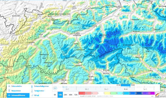
After an initially warm, then variable November it is snowing down to low altitudes in widespread parts of Tirol. The snowfall will be heaviest today (22.11), tomorrow it is expected to taper off everywhere. According to ZAMG Weather Service the main regions of precipitation lie in the Tux and Zillertal Alps, and the northern and southern parts of East Tirol, where up to 40 cm of fresh snow is expected at high altitudes. Southern Ötztal and Stubai Alps should get up to 30 cm, elsewhere 20 cm is anticipated generally.
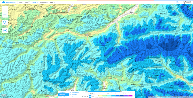

48-hr fresh snow forecast. Main areas of precipitation lie in the southeastern regions.


Southerly winds shifted to westerly/northwesterly, blowing mostly at moderate strength. They will intensify significantly at high altitudes over the coming days. Main wind direction will remain W/NW.
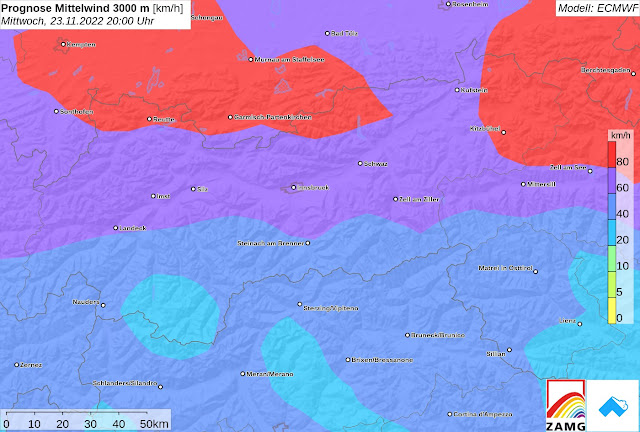

Windprognose für Mittwoch, 23.11. 20:00 Uhr
Wind forecast for Wednesday, 23.11. 8:00 pm


Considerable avalanche danger at high altitudes

The combination of snowfall, wind and the current snow layering is causing a significant increase in avalanche danger. At high altitudes, where the cohesive area-wide snowpack has persisted, we assume that avalanche danger will be considerable.  Wherever snowfall is heaviest are the least favorable regions of all. Danger increases with ascending altitude. Shady slopes tend to be at greater risk. Sunny slopes need to be evaluated critically, particularly near ridge lines and in high alpine terrain in general.


Ein Blick zurück: Wechselhaftes Wetter mit wiederkehrenden Niederschlägen, teilweise auch in Form von Regen.
A glance back: variable weather conditions, recurrent precipitation, sometimes as rain


The snowpack

The snowpack is a reflection of the sequence of weather conditions. Appropriately, we find a series of crusts and soft layers, the latter frequently composed of loose, faceted crystals, even depth hoar in some places. This constitutes a serious weak layer for the mass of fresh snow which lies on top of it (impacted by wind). The additional load of one single winter sports enthusiast can be enough to disturb the weak layer and trigger the release of a slab.


Schneeprofil in der Gurgler Gruppe vom 19.11.2022. 3065m, NW, 34° Mögliche Schwachschichten befinden sich in Oberflächennähe
Snow profile, Gurgl Massif, 19.11.2022. 3065m, NW, 34° Potential weak layers near the surface.


Schneeprofil in der Weißkugelgruppe vom 21.11.2022. 3050m, SO, 33°. In großen Höhen findet man auch im besonnten Gelände zumindest eine mögliche Schwachschicht für Schneebrettlawinen.
Snow profile in Weisskugel Massif, 21.11.2022. 3050m, SE, 33°.  There is at least one potential weak layer for slab avalanches even in sunny terrain at high altitudes.


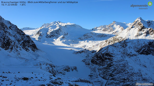
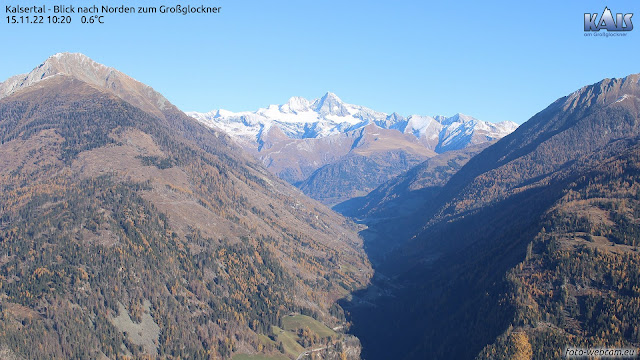
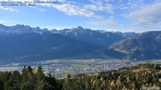
Web camera photos are extremely helpful in determining whether there was a cohesive area-wide snowpack prior to the current snowfall. Here are photos of where that was the case. More details at foto-webcam.eu.   


Blick ins Tuxertal, einem der bisher schneereichsten Gebiete Tirols. Foto vom 15.11.2022
View into Tux Valley, a region that has already had much snow. Photo from 15.11.2022


Hochalpines Gelände von 2800m aufwärts in der Weißkugelgruppe
High alpine terrain above 2800m in the Weisskugel Massif

Nördliches Osttirol. Südhänge waren bis in große Höhen aper.
Northern East Tirol. South-facing slopes were bare of snow up to high altitude.


In den Lienzer Dolomiten und am Karnischen Kamm lag vor den Schneefällen schattseitig bereits Schnee. Unseren Infos nach ist dieser oberflächig verkrustet, darunter häufig locker.
In the Lienz Dolomites and on the Carnic Ridge there was snow on the ground prior to the current snowfall. Our photos reveal it was encrusted on the surface, often loose below the crust.


A plea

In many places there is at least one ugly and threatening weak layer at high altitudes, on top of which is then a well-bonded mass of (fresh) snow. Thus: ideal prerequisites for a slab release. Due to the shallow covering of the weak layer, it can be triggered with relative ease by winter sports enthusiasts. Therefore: be careful, attentive and restrained in the mountains!

By the way, for a brief spell we are going to observe increasingly frequent glide-snow slides on grassy slopes in the regions where snowfall is heavy. In addition, loose-snow avalanches are expected in extremely steep terrain.

Saturday, 5 November 2022

Beware snowdrifts in high alpine terrain. Also loose-snow and glide-snow slides.

Cold front brings snowfall, most in northern Zillertal Alps

Over the last 24 hours there has been precipitation throughout Tirol, above approximately 1200 m as snowfall. Maximum precipitation was registered in the northern Zillertal Alps: as much as 40 mm from place to place. Widespread 10-20 mm was registered. This corresponds to approximately 10-20 cm of fresh snow. In the heights there were frequently strong winds blowing, initially southerly, then northerly.


Neuschneezuwachs der Kaltfront vom 04.11.2022
Increase in fresh snow delivered by the cold on 04.11.2022


Ein ähnliches Bild zeigt die Karte der 24h-Niederschlagssumme (04.11. auf 05.11. 08:00 Uhr) von Hydro Online.
A similar picture in this 24-hr overall snowfall map (04.11 - 05.11) by Hydro Online


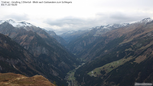
Nördliche Zillertaler Alpen vor Eintreffen der Kaltfront
Northern Zillertal Alps before the cold front arrived


Nördliche Zillertaler Alpen nach Eintreffen der Kaltfront - wohl nur ein kurzer winterlicher Eindruck
Northern Zillertal Alps after the cold front arrived. A brief foretaste of winter...


Effects of snowfall on avalanche danger

One potential avalanche danger can be observed widespread in the regions with the most recent snowfall. It stems from freshly generated snowdrift accumulations in shady, very steep terrain, namely above about 2800 m. The snowdrifts were deposited frequently on a weak surface layer of faceted crystals from October. Currently, small-to-medium sized slab avalanches can be expected. These releases can be triggered by the weight of a winter sports enthusiast in isolated cases. Increasingly frequently, it is likeliest to occur near ridge lines and behind steep protuberances in the terrain. Current weather forecasts foresee improving weather conditions and rising temperatures, so the fresh snow will settle rapidly and the danger will swiftly recede.

In addition this weekend, increasingly frequent small loose-snow slides can be expected in extremely steep terrain; as well as small slides of glide-snow on steep grass-covered slopes. 


Review


Weather

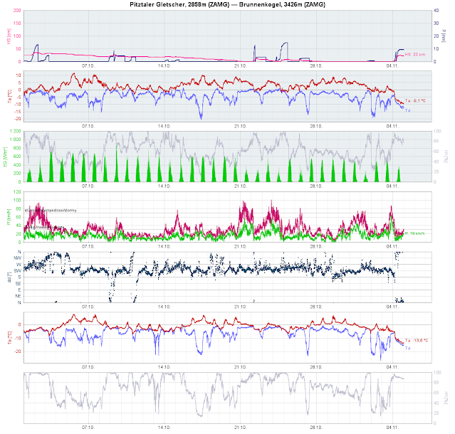
According to ZAMG Weather Service, we have just lived through the warmest October in the history of weather measurement. Their measurements go back to the year 1853.


Der Oktober 2022 war außergewöhnlich warm...
October 2022 was unbelievably warm...


Rückschau bis Anfang Oktober: Ein sonniger, außergewöhnlich warmer und eher niederschlagsarmer Oktober liegt hinter uns. Niederschlag fiel oftmals bis in großen Höhen in Form von Regen. Aktuell erkennt man den Temperaturrückgang aufgrund der Kaltfront samt Schneefall und Winddrehung.
A glance back to the beginning of October: a sunny, extraordinarily warm and precipitation-free month. Often at high altitudes the precipitation was registered in the form of rain. At the present moment we see a drop in temperature from the cold front including snowfall and shifting winds.


Snowpack

Before the cold front arrived on 4 November on shady slopes there was a more or less cohesive, area-wide snowpack above approximately 2800 m, on south-facing slopes only in high alpine glaciated terrain. Currently we don’t know much about the condition of the old snowpack, but assume that a melt-freeze crust has frequently formed on the surface. In sunny high alpine terrain that crust will be capable of bearing loads, in shady terrain it will be breakable. On shady slopes we expect to find a loose layer of faceted crystals from October beneath this shallow crust. That layer is currently the only significant weak layer we perceive which could unleash slab avalanches.


Schneeprofil vom 16.10.2022, 3170m, NO, 20° am Daunferner in den Zentralen Stubaier Alpen. Der Pfeil zeigt auf eine mögliche Schwachschicht unterhalb einer dünnen Kruste. (c) Lukas Ruetz
Snow profile from 16 October 2022, 3170m, NE, 20° on Daunferner glacier in the central Stubai Alps.
The arrow points to a potential weak layer beneath a thin crust. (c) Lukas Ruetz


Blick vom Kaunertaler Gletscher Richtung Süden. Ausgangssituation vom 03.11.. Eine mehr oder weniger zusammenhängende Schneedecke gibt es nur in großen Höhen, vermehrt im schattigen Gelände.
View from Kaunertal Glacier towards the south. This was our point of departure on 3 November.
A more or less cohesive area-wide snowpack existed only at high altitudes, particularly in shady terrain.


The next blog will be published whenever a significant change in the snow or avalanche situation occurs.