Snowpack rapidly becoming wetter
According to ZAMG Weather Service, a low over Italy is depositing moist air masses in the lower layers of the atmosphere. Winds are light, conditions variable, prone to showers. Snowfall above 2300 m.
In short: April weather in May.
 |
| “Steamy” weather, a high degree of moisture is making the snowpack wetter and wetter throughout the land. |
Thereby the snowpack is becoming increasingly moist or wet. This applies to all aspects. Our attention is riveted on shady slopes: above 2400-2500 m these slopes are becoming wet down to the ground for the first time and thus, particularly unstable.
 |
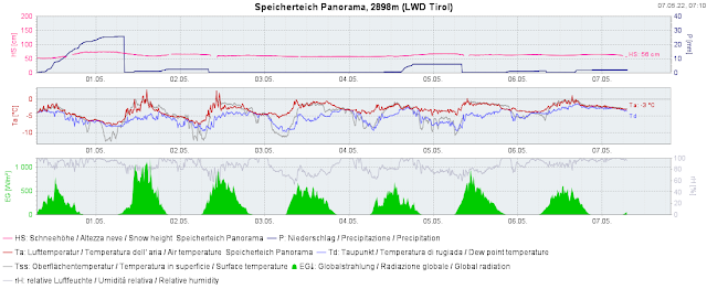
| One of our highest-altitude measurement stations in the Sölden ski area. Repeated bouts of precipitation. Slight daytime cycle of surface temperature, currently about 0°C. Similar situation for the thawing point. |
 |
| Compare that to the above weather station graph: at this station located 700m lower at the Jamtal refuge, the thawing point crosses the 0°C line - a clear signal for the snowpack being thoroughly wet. |
Increasingly frequent wet-snow avalanches
As mentioned, we anticipate increasingly frequent wet-snow avalanches which will fracture down deep particularly on shady slopes. Most of them will be loose-snow avalanches, a few will be small-to-medium slab avalanches. Altitude belt: 2400-2600m with a tendency to ascend over the next few days.
The recently deposited fresh snow will become especially unstable due to diffuse radiation influence. We expect numerous loose-snow slides and isolated medium-sized loose-snow avalanches on extremely steep slopes.
We should also not loose sight of the weak near-surface layers which have formed in high alpine regions due to dp.4 (cold on warm). These layers are of significance wherever there was ample snowfall during the last week, thereby blanketing the weak layer with a thick “slab.” We assume this means only very isolated avalanche prone locations. A quick view inside the snowpack and swift stability test brings clarity.
.jpg) |
| Fresh loose-snow avalanches in rear Kaunertal (photo: 05.05.2022) |
 |
| 24-hr fresh snow map for 30.04.2022. Most of the snow fell in East Tirol, and most avalanche activity was registered there for a short time. |
.jpg) |
| Fresh snow reacts quickly to warmth and radiation in springtime. Loose-snow avalanche in the Deferegger mountains. (photo: 01.05.2022) |
The spring is unstoppable...
The ZAMG Weather Service forecasts variable, prone-to-showers conditions for the next few days, with rising temperatures. Starting on Tuesday it will become warm like in summer. The deeply penetrating wetness of the snowpack is progressing to ever higher altitudes quite rapidly. Special caution is urged on shady slopes at high altitudes.
.jpg) |
Below, spring; above springtime conditions. Kleiner Kasseler in the northern Zillertal Alps
(photo: 29.04.2022) |
.jpg) |
| En route in Central Stubai Alps. Carrying your skis has become the norm... (photo: 04.05.2022) |
Blogs will be published only irregularly starting in May, namely, whenever the avalanche situation changes significantly.

.jpg)

.jpg)
.jpg)
.jpg)

